Friday, January 27, 2023

All That Glitters Is Not Gold (and Not All Brown Cherts Are Knife River)

All That Glitters is Not Gold
(And Not All Brown Cherts Are Knife River)
by John Bradford Branney


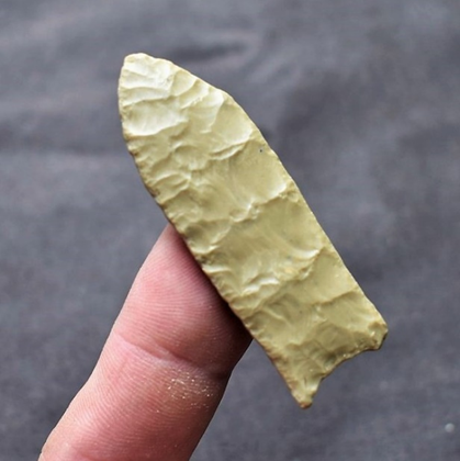
Figure One - 3.8-inch-long Besant knife form made from Knife River and surface found
on private land near New Town, North Dakota by Sherry Christianson.
Note color, white/yellow splotches, plant fossils, loose hinges, and patina.
John Bradford Branney Collection. 

I am an artifact hunter and prehistorian who spends much of my spare time hunting rocks on the high plains of Wyoming and Colorado. When I think about the most popular raw materials for toolmaking during high plains prehistory, I think of beautiful Hartville Uplift Jasper or Spanish Diggings Quartzite or Flattop Chalcedony, or the subject of this article: Knife River Chalcedony. I would be remiss if I did not mention that there were literally hundreds of different types of raw materials from Alberta, Canada to the Panhandle of Texas for prehistoric people to choose from. Some of those raw materials have local or regional names such as Big Horn Chert or Pryor Creek Jasper or Black Forest Silicified Wood while other raw materials just go by a generic rock type name such as moss agate, tiger chert, or caramel-colored jasper. Maybe someday I will write an article about the less glamorous high plains raw materials. 


Figure Two - BEYOND the CAMPFIRE, the fifth book in the
SHADOWS on the TRAIL Pentology. 

Based on archaeological evidence, it is clear that prehistoric people sought the highest quality raw material that was available to make their tools and projectile points. The ideal raw material fractured conchoidally in a predictable manner and was not too soft or brittle to hold a sharp working edge. Besides availability and quality, a rock type’s flashiness was also a factor for prehistoric people. Knife River Chalcedony checks all the boxes; it was available and of high quality, and it was definitely beautiful. Based on archaeological evidence, prehistoric people went out of their way to scavenge and use Knife River Chalcedony.

You will notice that I called Knife River a chalcedony, but Luedtke (1992:6) would argue with my definition. Luedtke pointed out that chalcedony is the only variety of chert that scientists can identify microscopically by its fibrous form. Those fibers cannot be seen with the naked eye. Luedtke proclaimed that while most cherts made from chalcedony were translucent, not all translucent cherts were chalcedony. She added that Knife River was the perfect example of a translucent chert that was not a chalcedony but a granular quartz, and not a fibrous quartz.


Figure Three - Note Knife River translucency on this 2.5-inch-long Middle Archaic Oxbow
Knife Form surface found on private land near Gillette, Wyoming by Chuck Carlson.
John Bradford Branney Collection.   

The most popular name for Knife River Chalcedony by far and used by archaeologists and collectors alike is Knife River Flint which is oftentimes abbreviated as KRF. According to Luedtke (1992:140), the definition of flint is a “homogenous, high quality chert, especially the dark gray or black cherts that form in the Cretaceous chalks of Europe”. That does not fit Knife River any more than the definition of chalcedony does. The most accurate name is probably Knife River Chert because the term chert casts a wide net by including most varieties of microcrystalline quartz.

Since an old habit is hard to break, I will refer to the rock type as either Knife River Chalcedony or just plain Knife River for this article. Secondly, I will refer to Knife River Chalcedony as semi-translucent even though some authors prefer to call it translucent. When I think of something translucent, I think of a clear pane of glass, and Knife River is not as translucent as a clear pane of glass.   

Luedtke (1992:6) described Knife River as a very dark brown, fine-textured, silicified lignite with a medium luster and a depth of translucency from 5 to 11 mm. Bates and Jackson (1984:295) defined lignite as a brownish-black coal that was intermediate in coalification between peat and sub-bituminous coal. The adjective silicified describes a process where organic matter, in this case lignite, became saturated and replaced by silica in the form of quartz, chalcedony, or opal.  


Figure Four - 2.8-inch-long Goshen spear/knife form surface found on private land in the 
Sand Hills of Lincoln County, Nebraska. John Bradford Branney Collection.  

Kristensen et al. (2018:22) analyzed Knife River using macroscopic, microscopic, and geochemical techniques and supported the description that the rock type was silicified lignite. The authors described the color of Knife River as blonde to dark coffee brown and stated that the rock type could possess high translucency, visible bedding planes, plant microfossils, and white splotches. The authors also declared that by just using visual inspection, Knife River could not be discerned from silicified peat or chalcedony.

Geologists know very little about the origin of Knife River Chalcedony because it is only found in secondary deposits and not in its original geological context. Hickey (1966:64-5) suggested that based on its high carbon content, plant fossils, and proximity to unsilicified lignite, Knife River originally formed as a deposit of organic lignite in the Eocene geological period. He surmised that later in the Oligocene geological period, silica-rich groundwater saturated the lignite, creating a hard silicified lignite layer. Kristensen et al. (2018:3) reported that by the time Paleoindians showed up to exploit the rock type in the late Pleistocene geological period, the silicified lignite bed was eroded away and broken up into pebbles, boulders and cobbles of Knife River.  


Figure Five - Knife River nodules found in secondary geological contexts from eroded bedrock outcrops that no longer exist. The images on the left and top right are courtesy
of David McDonald. The bottom image on the right is courtesy 
of the Archaeology and Historic Preservation Division, 
State Historical Society of North Dakota.

Clayton et al. (1970) expanded on that interpretation by postulating that the original Knife River lignite bed was initially surrounded by the clays, silts, and sands of the Golden Valley Formation of Eocene age and underlain by the clays, silts, sands, and lignite beds of the Sentinel Butte Formation. Earlier, Benson (1949, 1952) informally divided the Golden Valley Formation into two members, a brightly colored claystone called the Bear Den Member of Paleocene age, and an overlying unit called the Camels Butte Member of Eocene age. Both members were deposited roughly between 50 and 57 million years ago.


Knife River’s color is often compared to “root beer, coffee, or beer bottle” with a touch of translucency. Many prehistoric artifacts made from Knife River are beautiful and glow in vivid shades of brown when backlit (figure three). I have seen collectors pay a pretty penny for prehistoric artifacts made from a desirable chunk of Knife River raw material. Market demand combined with a plethora of lookalike materials from Texas to Alberta led to the overidentification of Knife River as the raw material. Collectors and archaeologists must be careful when they use visual inspection alone to identify Knife River from other semi-translucent brown cherts or chalcedonies.


Figure Six - Agate Basin spear/knife forms made from semi-translucent to opaque Knife River 
and surface found on private land from North Dakota to northern Colorado. These
examples show color variation, white splotches, hanging hinges, and patina.  
The longest Agate Basin is 4.7-inches-long.
John Bradford Branney Collection.  

I have quite a few prehistoric artifacts in my collection made from Knife River Chalcedony, found from the Dakotas and Montana through Wyoming and south to northern Colorado. The artifacts range in color from very dark brown to honey-colored brown. Most of my Knife River artifacts exhibit a certain degree of translucency, but I have a couple of nice examples that are completely opaque. When I visually inspect an artifact, I use five characteristics to identify Knife River. The first characteristic is its color as described in a few sentences above. The second characteristic is the silicified plant fossils or palm fronds captured in the matrix of the rock. The third characteristic is a distinctive white-to-yellow patina caused by chemical weathering and commonly found on Knife River artifacts. The fourth characteristic is the distinctive white and yellow opaque splotches on the surface of the rock or locked into the matrix. The fifth characteristic that cannot be used as a diagnostic feature for Knife River but is quite common on Knife River artifacts is loose hinge fractures, even when the artifact was found in freeze-thaw country.  I have examples of Knife River artifacts with all five characteristics and I have suspected Knife River artifacts with none of those characteristics. If a person does not notice at least one of those characteristics, they might be looking at a Knife River lookalike.     

A few artifact collectors and authenticators believe that UV irradiation can be effectively used to identify Knife River as the rock type and for authenticating Knife River artifacts. That theory contends that authentic Knife River artifacts fluoresce under either short or long-wave UV light. The assumption is that authentic artifacts are aged and chemically weathered therefore they fluoresce, while the fresh surfaces on artifact reproductions won’t fluoresce. One authenticator even told me that authentic Knife River artifacts emit an orangish color under UV light when they are authentic. To test that theory, I did my own experimentation with a few of my Knife River artifacts. I did not obtain the same results as the authenticator. Of the artifacts that did fluoresce, some appeared slightly orange while others appeared almost white or some shade in between. A few artifacts fluoresced so weakly that I needed my imagination to see any fluorescence, and a few artifacts did not fluoresce at all. To ensure that the Knife River artifacts did not need to be a certain age to fluoresce, I experimented with artifacts ranging from Paleoindian to Late Prehistoric times. I concluded that using UV irradiation as a method for determining rock type or authentication of Knife River artifacts was indefinite at best.


Figure Seven - Lookalike material or Knife River Chalcedony? Several professionals and 
collectors have looked at this 1.8-inch long Folsom dart point, both macroscopically and 
microscopically and we have a hung jury on whether it is Knife River or not. 
John Bradford Branney Collection.  

Kirchmeir (2011:27) and Kristensen et al. (2018:14) experimented and determined similar results with UV radiation and Knife River. The investigators noted that artifacts made from similar materials, such as brown chalcedony and silicified peat, fluoresced in a similar manner as Knife River. In their studies, Knife River and lookalike materials showed such a wide range of fluorescence to non-fluorescence that the process was not useful for the identification of the raw material. The investigators warned that chemical weathering of the rock could enhance or obscure its fluorescence. Their conclusion was that UV irradiation was not an effective standalone technique for the identification of Knife River and should only be used in concert with other macroscopic, microscopic, and geochemical analyses.

What separated Knife River from most high plains raw materials were its overall abundance and wide distribution. The archaeological evidence that Knife River traveled far from its source during prehistoric times is overwhelming. The rock type originated from a network of rock quarries in North Dakota that supplied a vast amount of tool stone for prehistoric humans for thousands of years. Knife River’s popularity is reflected in the number of prehistoric tools made from it, the quarries’ endurance over prehistoric times, and the rock type’s dispersal across the plains.


Ahler (1986:105) estimated that prehistoric people quarried around 12.5 million kilograms (20,393 tons) of Knife River Chalcedony from roughly thirty quarry sites in a primary source area of approximately 2,000 square kilometers (772 square miles) in Dunn and Mercer Counties in North Dakota. From his estimates, Ahler calculated that prehistoric people made around 640 million tools and cores from Knife River and spread those tools and cores over an area of approximately 3.7 million square kilometers (1.4 million square miles). Whether Ahler’s estimations were accurate or not we will never know for sure, but even if we divide Ahler’s estimates by a factor of twenty, the numbers remain staggering. Knife River Chalcedony was quite popular with the prehistoric folks!


Figure Eight - Lookalike material or Knife River? This root-beer colored Scottsbluff point was 
surface found on private land near Green River, Wyoming. Artifact authenticator Greg Perino
identified the material as Knife River, but it could be one of the local brown chalcedonies
found in that region. The point is 2.5-inches-long. John Bradford Branney Collection. 
     

Steuber (2018) addressed the wide distribution of Knife River by determining whether or not archaeologists and collectors were overidentifying Knife River on the high plains. She challenged the entrenched professional view that Knife River was the dominant material in Besant/Sonota prehistoric cultural sites on the Northern Plains. Steuber chemically analyzed twelve brown chalcedony sources across three Canadian Provinces and three American States. She then compared her chemical analysis with material labeled as Knife River at archaeological sites. She concluded that Knife River was not the dominant lithic raw material at those archaeological sites after all and that the prehistoric inhabitants were exploiting local varieties of brown chalcedonies and not as much Knife River as previously reported. Steuber concluded her analysis by quoting, “All artifacts made from brown chalcedony should be referred to as such and not as KRF unless they have been previously geochemically characterized”.  

I have discovered several prehistoric rock quarries and mining operations in my search for prehistoric artifacts on the high plains and I can conclude that while the raw materials at those quarries met the knapping and durability requirements for toolmaking, the distribution never came close to the Knife River supply chain. Knife River Chalcedony was one of the kings of high plains raw material for thousands of years.      


References Cited

Ahler, S.A. 1986. Knife River Flint Quarries: Excavations at Site 32DU508. State Historical Society of North Dakota, Bismarck, North Dakota.

Bates, Robert L. and Julia A. Jackson. 1984. Dictionary of Geological Terms. Third Edition. Anchor Press/Doubleday. New York.

Benson, W.E. and Laird, W.M., 1947, Eocene of North Dakota: abstract, Geological Society of America Bulletin, v 58, p. 1166-1167.

Benson, W.E., 1952, Geology of the Knife River area, North Dakota: U.S. Geological Survey Open-File Report, 276 p.

Clayton, L., W.B. Bickley, Jr., and W.J. Stone. 1970. Knife River Flint. Plains Anthropologist 15:282-290.

Hickey, L.J. 1966. The Paleobotany and Stratigraphy of the Golden Valley Formation in Western North Dakota. Ph.D. dissertation, Department of Geology, Princeton University, Princeton, New Jersey.

Kirchmeir, P.F.R. 2011. A Knife River Flint Identification Model and its Application to Three Alberta Ecozone Archaeological Assemblages. M.A. thesis, Department of Anthropology, University of Alberta, Edmonton, Alberta

Kristensen, Todd, Emily Moffat, M. John, M. Duke, Andrew J. Locock, Cody Sharphead, and John W. Ives. 2018. Identifying Knife River Flint in Alberta: A silicified lignite toolstone from North Dakota. Occasional Paper No. 38. Archaeological Survey of Alberta.  

Luedtke, Barbara E. 1992. An Archaeologist’s Guide to Chert and Flint. Archaeological Research Tools 7. Institute of Archaeology. University of California, Los Angeles. 

Steuber, Karin Ingrid. 2018. Geochemical Characterization of Brown Chalcedony during the Besant/Sonota Period. Ph.D. Dissertation. Department of Archaeology & Anthropology, University of Saskatchewan, Saskatoon.


About the Author


John Bradford Branney has hunted and collected artifacts for six decades and he has written about his adventures for around three decades. Join Author Branney for his high plains saga about the lives of Paleoindians some twelve thousand years ago in the SHADOWS on the TRAIL Pentalogy. His books are available on Amazon.com or wherever fine books are sold.     

Monday, December 26, 2022

Alibates Agatized Dolomite - Rock Types Along the Trail

 by John Bradford Branney


Figure One - Artifacts from the author's collection, made from various flavors of Alibates  
agatized dolomite. Tear-drop ultrathin knife form to the right is 3.25 inches long.    


My story begins thirty-five or so miles northeast of Amarillo, Texas on what is now known as the Alibates Flint Quarries National Monument. The monument encompasses 1371 acres with over 700 visible prehistoric mining pits. For 13,000 years or more, prehistoric humans mined a special rock type that they used to make their projectile points and stone tools from the quarries. In the following paragraphs, I will delve into some of the history, prehistory, and geology surrounding a special rock type known as Alibates agatized dolomite. 

 Alibates National Monument around Lake Meredith. 
Graphic by Jason Kenworthy
(NPS Geologic Resources Division).
 
Alibates agatized dolomite is a very distinctive, multicolored rock with colors ranging from maroon to red and gray to black. Mix in a little white and tan with bands of pink, blue, purple, yellow, purple, brown, and cream, and Alibates agatized dolomite exhibits a rainbow of colors (figure one).

Although Alibates agatized dolomite is the rock type’s “official” name, collectors and professionals alike refer to it by other names such as Alibates, Alibates chert, Alibates jasper, Alibates dolomite, Amarillo flint, Beef Steak Alibates, Quartermaster flint, and Alibates silicified dolomite. In this article, I will refer to the rock type as either Alibates agatized dolomite or just plain Alibates.

According to several modern-day flintknappers I spoke to, Alibates can have a resistant quality and hardness that makes it difficult to sometimes knap. As popular as Alibates was during prehistoric times, based on its wide geographical range, prehistoric flintknappers must have ignored the rock’s finicky nature and instead focused on its exotic colors and banding. I believe that Alibates probably mesmerized prehistoric humans just like it does some of us today. Alibates agatized dolomite is not only pleasing to the eye, but perhaps prehistoric humans believed the rock enhanced their hunting success. 

     Figure Two - Boulders of white Alibates Dolomite cascading
down hills at Alibates Flint Quarries NM. NPS Photograph. 


How did the name Alibates agatized dolomite come about? Gould (1907) first described the agatized dolomite a mile and a half south of the national monument along Alibates Creek in Potter County, Texas. A local rancher named the creek after his cowboy son, Allen “Allie” Bates, and Gould named the rock type after the creek where he found it. Agatized is an adjective describing the geological process that creates the rock type called agate, which is a striped or banded, sometimes translucent, cryptocrystalline variety of quartz. And the last word in the rock type’s description, dolomite, is a common, rock-forming mineral that I will discuss later in the article. 

Meltzer (2006:250) added some flavor to the origin of the name Alibates agatized dolomite by relaying the following story. In 1926, excavations began at the original Folsom site in New Mexico. In 1928, the American Museum of Natural History joined the Folsom excavation with vertebrate paleontologist Barnum Brown in charge. In November of 1930, Oklahoma State Geologist Charles Gould sent Barnum Brown a package of Alibates agatized dolomite. Gould acquired his experience in Texas Panhandle geology several decades prior to 1930. Gould also happened to be the first person to map and describe the Alibates Dolomite Formation where the agatized dolomite came from. 

Figure Three - The Drake Clovis Cache. One of the 
most famous examples of mostly Alibates artifacts
found on the high plains of northern Colorado. 

Barnum Brown did not agree that the rock samples Gould sent him were agatized dolomite. Brown believed the rock samples were jasper, a variety of chert containing iron-oxide impurities which gave the rock type a wide range of colors, especially red. Being an experienced geologist, Gould knew exactly where the rock samples came from. He replied to Brown that the rock samples “formed a constituent part of a ledge of dolomite that outcropped over parts of the Panhandle of Texas”. Gould added that the best site for finding Alibates agatized dolomite was “on the bluffs overlooking the south Canadian River”.


Barnum Brown and Charles Gould probably agreed to disagree on the rock type, but Brown and his associates confirmed that Paleoindians used Alibates agatized dolomite to make projectile points and stone tools at the Folsom site in New Mexico. Long and short of it, the label Alibates agatized dolomite prevails even today.  

The dolomite “on the bluffs overlooking the south Canadian River” that Charles Gould referred to was a fifteen-foot-thick bed of agatized or silicified dolomite and mudstone that geologists call the Alibates Dolomite Formation or the Alibates Dolomite for short. That formation contains three informal members: a lower gray dolomite which is resistant enough to form ledges, an upper brecciated and fractured upper gray dolomite that supplied most of the agatized dolomite, and a red to brown calcareous mudstone sandwiched in between the two dolomites. The Alibates Dolomite Formation lies above the red beds of the Permian Whitehorse Formation and lies below the red beds of the Permian Quartermaster Formation. Geologists often refer to that entire sequence of rocks as the Permian Red Beds. The twelve-million-year-old Ogallala formation from the Miocene-Pliocene Epochs lies directly on top of the two-hundred-sixty-million-year-old Permian Red Beds in what geologists call the Great Unconformity, a massive gap in the geologic record.    


It is now time for us to board our time machine for a little geology lesson. I am setting the dial of our machine for around two hundred fifty-five million years ago during the Permian Period. At that time, North America, and most of the rest of the world were not geographically located where they are today. Texas was situated along the equator and was a small part of a supercontinent named Pangea. During that time period, Texas landscapes were a combination of coastal plains, marine basins, and tidal flats. The Permian Red Beds for the most part were terrestrial deposits and formed alongside a great ocean that extended up from the south.

Figure Four - Pangea in Late Permian. Texas and the Alibates National Monument are
 located near the Equator at the southwestern end of the Central Pangean Mountains. 
   

Throughout geologic time, climate change has been a big factor in determining both weather and landscape, and the Late Permian in Texas was no different. When colder global climates occurred, thick ice caps grew in the north and south parts of Pangea. To grow, the ice caps borrowed water from the oceans which resulted in lower sea levels and more landmass. During that time in Texas, river and stream systems deposited hundreds of feet of relatively soft shale, sandstone, and mudstone, including where the Alibates National Monument lies today.   

When the climate reversed and warmed up, the ice caps melted, and the water returned to the seas. Sea levels rose and inundated the land with seawater, stretching from the Arctic Ocean near Alaska on the north, through Canada and the United States, and connecting with the Pacific Ocean in Mexico. When sea levels dropped again, lower-lying basins trapped the seawater, and when that water evaporated, it left behind organic matter and salt. That was how thin beds of gypsum formed in the national monument area and the main reason why the Canadian River tastes salty even today. And how was the Alibates Dolomite Formation created?      

Dolomite is a common rock-forming mineral and in its pure state, it is white to light-colored. Chemists specify dolomite as CaMg(CO₃)₂. Jackson (1970:176-178) and Scholle et al. (1983:194-195) studied the modern-day creation of dolomite deposits and reported that the formation of dolomite occurs along the ocean in hot, dry climates, a few inches above high tide in a zone referred to as the supratidal, or the splash or spray zone. The scientists proposed that dolomite started out as calcium carbonate (CaCO₃) in the form of calcite and aragonite sediments, mostly consisting of the remains of plankton, coral, algae, and shelled animals. Seawater soaked the supratidal zone during storm surges and abnormally high tides. Seawater also saturated the supratidal zone from underneath as capillary action pulled seawater to the surface of the zone (figure five). When the seawater evaporated, it left behind magnesium-rich brines which chemically reacted with calcium carbonate to form dolomite. 


Figure Five - Schematic diagram showing sedimentary environments from continental 
to marine, their relationships to sea level, and the relative amounts
of capillary action (Scholl et al. 1983:172). 

For agatization or silicification to occur, silicon dioxide must replace the original dolomite. Bowers and Reaser (1996) reported that at the Alibates National Monument, a silica-based mineral called chert completely replaced the dolomite in the upper dolomite member while only partially replacing the dolomite in the lower member. That led the investigators to conclude that the agatization or silicification process occurred from the top down with the upper dolomite member acting as the main host rock for silica solutions. Bowers (1975) stated that minor amounts of aluminum, iron, and manganese were deposited with the silica in the dolomite and those minerals account for the beautiful bands and colors found in Alibates agatized dolomite.              

Where did the silica come from that agatized or silicified the dolomite? Since the overlying rocks above the Permian Red Beds were eroded away, scientists can only speculate as to the source of the silica. The U.S. National Park Service (2022) provided three theories for the origins of the silica in the dolomite. The first theory entails an eruption of a Yellowstone super-volcano around 675,000 years ago provided silica via volcanic ash. Around Lake Meredith, there are several locations where there is a three-foot thick bed of Yellowstone ash. The theory goes that when it rained, some of the silica-rich ash dissolved into the rainwater and percolated down through the dolomite. Another theory is that the deposition of the Ogallala Formation sediments brought silica-rich material with it. The third theory, the National Park Service proposed was that silicification occurred at the same time as the dolomite formed, but for that to occur, perfect conditions were in order.  

We may never know for sure but what we do know for sure is that Alibates agatized dolomite is a beautiful and desirable rock type for artifacts!         


Bowers, R. L., 1975. Petrography and petrogenesis of the Alibates dolomite and chert (Permian), northern Panhandle of Texas [M.S. thesis]. The University of Texas at Arlington, Arlington, Texas, 155 pp.

Bowers, R. L., and Donald F. Reaser, 1996. “Replacement Chert in the Alibates Dolomite (Permian) of the Texas Panhandle”. The Texas Journal of Science.    

Gould, C. N., 1907, “Geology and water resources of the western portion of the Panhandle of Texas”. U.S. Geological Survey Water Supply Paper 191, pp. 1-70.

Jackson, Kern C., 1970, Textbook of Lithology, pp. 176-178. McGraw-Hill Book Company. New York.

Meltzer, David J., 2006, Folsom: New Archaeological Investigations of a Classic Paleoindian Bison Kill. University of California Press. Berkeley.  

Scholl, Peter A. Don G. Bebout, and Clyde H. Moore, Carbonate Depositional Environments, AAPG Memoir 33, pp. 194-195. The American Association of Petroleum Geologists. Tulsa.

U.S. National Park Service, 2022, Geology-Alibates Flint Quarries National Monument (nps.gov).


The historical fiction novels written by John Bradford Branney are known for their impeccable research and biting realism. In his latest blockbuster novel Beyond the Campfire, Branney catapults his readers back into Prehistoric America where they reunite with some familiar faces from Branney’s best-selling prehistoric adventure series the Shadows on the Trail Pentalogy.


John Bradford Branney holds a geology degree from the University of Wyoming and an MBA from the University of Colorado. John lives in the Colorado mountains with his wife, Theresa. Beyond the Campfire is the eleventh published book by Branney.         

Saturday, December 10, 2022

Permineralization Amongst the Shadows on the Trail.


Figure One - From left to right: the distal end of a fossilized mammalian tibia and two
fossilized mandibles with alveoli (bony sockets) with partial teeth.
Species are unknown. For scale, the tibia is 4.3 inches long.


In this article, I will briefly discuss a fossilization process called permineralization and show four examples of the process found in the field. The Dictionary of Geological Terms by Robert L. Bates and Julia A. Jackson defines permineralization as the process of fossilization wherein the original hard parts of an animal have additional mineral matter deposited in their pore spaces.     

Figure one is a photograph of three fossilized mammal bones that I surface found in the sand of a dry creek in northern Colorado on 12/6/2022. On the left, is the distal end of a mammal tibia and on the right are two mammal mandibles showing the alveoli with a few broken teeth remaining within. Although these fossils were surface finds and I found them out of their original geological context, I am guessing they are from the Oligocene geological epoch since that was the rock outcrops that surrounded the dry creek. If they came from the fossil record of the Oligocene, that would put the mammals that left the fossils behind in an age group between thirty-four to twenty-three million years old.  

When an organism dies in nature its remains usually follow the “dust to dust” routine and slowly disintegrate into the soil. Organisms are rarely preserved intact for the fossil record. If Mother Nature preserves any portion of an animal or tree, it is usually the hard body parts like bone, wood, or shell. For those durable body parts to become fossilized, a quick burial must happen to protect them from further decay and destruction. Once buried, soil conditions and groundwater determine the survivability of the rest of the remains.

Figure Two - A slab of silicified palm wood or Palmoxylon, surface found by the author
in Washington County, Texas around the year 2012. Note the orientation of
the thin tubes. The scale is 6.3 inches long for the slab.    

Anyone who has lived in an area with untreated ‘hard water’ knows what their pipes and plumbing fixtures look like after a few years. Those people witness the evidence that groundwater is not pure H₂O. There are other minerals in the water. As water moves through the ground, it dissolves organic matter from the soil, making the liquid slightly acidic. Rainwater that permeates the soil and recharges aquifers carries CO₂ with it from the atmosphere and becomes a weak carbonic acid or H₂CO₃. As that acidic water moves through the ground, it is corrosive enough to dissolve minerals such as calcite, silica, and iron from the surrounding soil and bedrock. 

Figure Three - Same Palmoxylon slab as in figure two, looking straight down at the rodlike
structures that parallel the original axis of the trunk of the palm tree.
The slab is 6.3 inches long.   

Figures two and three are photographs of a piece of fossilized palm wood or Palmoxylon that I surface found in Washington County, Texas, sometime around the year 2012. Palmoxylon is the state rock of Texas and it is an extinct genus of palm trees that grew from the late Cretaceous to the early Miocene (eighty-three to eleven million years ago). The thin tubes or rodlike structures in figure three parallel the original orientation of the trunk of the palm tree. For permineralization or silicification to have occurred in this example, the original wood cell walls were permeable to groundwater flow and the tree decayed slowly enough to allow silicate minerals in the groundwater to replace the original woody structure.  
 
Figure Four - Fossilized skull from an unknown mammal
species found in a dry creek bed on 12/6/2022. 
The skull is 3.7 inches long.  


For the process of permineralization to work, the original material must be porous and permeable. Bones, wood, and shells may look solid, but they contain minute voids and pore spaces. Mineralized water advances through the soil and penetrates the pores spaces of the original material. When the water evaporates, the minerals drop out of the solution and remain in the pore spaces. Over hundreds or thousands or millions of years, the process repeats itself and creates layers upon layers of mineral deposits in the pores and voids of the original bone, wood, or shell. The minerals preserve the original shape and integrity of the host and prevent tissue compaction. The permineralization process literally turns bone or wood or shell into rock.  


Figure Five  - More permineralization examples of mammalian mandibles that I
surface recovered from Oligocene and Miocene rock in northern Colorado.
The longest example is 2.1 inches long. Species are unknown.   


The historical fiction novels written by John Bradford Branney are known for their impeccable research and biting realism. In his latest blockbuster novel Beyond the Campfire, Branney catapults his readers back into Prehistoric America where they reunite with some familiar faces from Branney’s best-selling prehistoric adventure series the Shadows on the Trail Pentalogy.

John Bradford Branney holds a geology degree from the University of Wyoming and an MBA from the University of Colorado. John lives in the Colorado mountains with his wife, Theresa.


Thursday, September 15, 2022

Unwinding a Twister - Goshen-Plainview and Midland


Unwinding a Twister – Goshen-Plainview and Midland
by John Bradford Branney


Figure One – A handful of Goshen, Plainview, Midland, and Folsom points from my collection. These were surface found in Kansas (1), Texas (1), and Colorado (3). Can you guess which is which?


Figure one shows a photograph of five projectile points from my collection. These points were all surface finds, recovered out of archaeological and geological context. I have classified these points as Paleoindian-made based on my experience at projectile point identification. I determined that there are probably four projectile point types in this batch of five. The objective for this photograph is to show readers how difficult and subtle it is to categorize projectile points that have many of the same features.

Originally, archaeologists interpreted the sequence of Goshen to Folsom to Midland to Plainview as more or less a serial transition, moving from one projectile point type to the next while the culture and lifestyle of the people making the projectile points remained much the same. Radiocarbon dating on old and new archaeological sites challenges the original interpretation of that serial transition.

In my article, Goshen-Plainview Dilemma (Branney 2017), I explored the relationship between the Goshen Complex on the northern plains to the Plainview Complex on the southern plains. In that article, I recounted how several investigators believe that Goshen and Plainview projectile points are morphologically and technologically the same projectile point type. Figure two shows Goshen, Plainview, and Midland points from the Mill Iron site of Montana and the Plainview site of Texas. I challenge readers to identify each point type without peeking at the caption describing the photograph. It is difficult to see much difference between the projectile points even though the photograph represents three projectile point types!


Figure Two – Goshen, Plainview, and Midland projectile points. Can you tell the difference without reading the above caption? The photograph was taken from The Mill Iron Site (Frison 1996)  

The concern that kept Goshen and Plainview separated into two projectile point types for decades wasn’t their morphology or technology, it was their age relative to the Folsom Complex. At the Hell Gap site in Wyoming, investigators found that Goshen was older than Folsom while earlier investigators at the Plainview site in Texas found that Plainview was younger than Folsom. Therefore, the investigators at Hell Gap concluded that they must have a different projectile point type (Frison 1996: p. 1-2)! In my article, I covered how recent scientific work was unraveling the age discrepancies between Goshen on the northern plains and Plainview on the southern plains. It appears that the Goshen-Plainview technology overlapped in time with Folsom technology and that Goshen-Plainview technology can be both younger and older than Folsom (Waters et al. 2014).


Based on the radiocarbon dating and analysis of projectile points at several Goshen and Plainview sites, investigators proposed that Goshen on the northern plains was technologically the same thing as Plainview on the southern plains. They proposed that Goshen-Plainview technology began in the north as Goshen and eventually migrated to the south where earlier archaeologists dubbed the technology, Plainview (Waters et al. 2020; Holliday et al. 2017). Another way of putting that theory is that it appears that Plainview projectile point technology was the southern extension of Goshen projectile point technology to the north.

In my article, I suggested that it was unnecessary to have both projectile point types, i.e., Goshen and Plainview, for what seems to be the same technology. Since investigators ‘christened’ Plainview before Goshen, there was now ample evidence to drop the Goshen name. However, since my words are not gospel by any stretch of anyone’s imagination, I will refer to the lithic assemblages of Goshen and Plainview as the Goshen-Plainview continuum.

I will now delve into the relationship between Goshen-Plainview, Folsom, and Midland and I will then opine on whether one of these projectile point types should drop in favor of the other two. In looking at the three projectile point technologies, it is readily apparent that Folsom is unique enough to stand on its own distinguishable characteristics. For Folsom, there is no debate. However, in my opinion, there is room to debate whether we need two projectile point types for Goshen-Plainview and Midland. That question becomes even more relevant when we look at the results of radiocarbon dating which indicates that Goshen-Plainview, Folsom, and Midland overlapped in time. We already know from archaeological evidence that we find them in the same geographical space.


Figure Three – Age ranges for five high plains Paleoindian complexes.


I guide you to my hand-drawn, ‘primitive’ jotting in figure three. The chart shows some of the latest projected age ranges for five high plains Paleoindian complexes. On the far right, I cite the scientists who have proposed age ranges based on updated radiocarbon dating. I have previously documented the pros and cons of the radiocarbon dating method, so I won’t revisit that in this article (Branney 2019). In some cases, the scientists back up the radiocarbon dating with stratigraphic and geologic relationships between the Paleoindian complexes. I will leave it up to readers to research the conclusions of these papers on their own.     

The X-axis on figure three reads ‘years ago’. I scaled that axis from 13,000 to 10,000 years ago. The Y-axis shows the respective Paleoindian complex from Clovis to Midland. The bars below the name of each complex represent the proposed age range based on the work of the scientists listed on the far right. For example, Michael Waters and associates (2020) proposed in their paper that the age of Clovis was around 13,050 to 12,750 years ago while Marcel Kornfeld (2013) quoted the age range for Folsom around 12,900 to 12,200 years ago.  


The key takeaway from figure three is the generous amount of temporal overlap for the different Paleoindian complexes. That leads me to believe that there is a high probability that Paleoindians were using multiple projectile point technologies/designs at the same time and place. In this day and age with all the archaeological evidence currently available, that conclusion is not exactly earthshattering, but when I was growing up in the 1960s, books on high plains archaeology tended to lean toward Paleoindian projectile point evolution/development as more of a serial process than a parallel process. The early books I read noted that Clovis was first, then came Folsom, followed by Agate Basin, Hell Gap, Cody Complex, and others. That made for a nice, simple story that was easy to follow, even though it appears now that Paleoindian projectile point evolution was anything but simple. The transition from one type of Paleoindian projectile point overlapped with its predecessor in both time and space. My cartoon image in figure three allows readers to visualize the proposed timeline based on the cited archaeological papers and books.

You will note that in figure three I have dashed the line for Midland because scientists have yet to define the age range for Midland. Most investigators believe that Midland and Folsom were somehow related, and current archaeological evidence establishes that Midland is slightly younger or coeval with Folsom.  

Let me now delve into the technological relationship between Goshen, Plainview, Midland, and Folsom. I will begin with Midland points. An amateur archaeologist by the name of Keith Glasscock reported to archaeologists what would become the Scharbauer site in Texas, the Midland projectile point type station (Wendorf et al. 1955). Glasscock surface recovered several fluted Folsom projectile points along with a few unfluted Folsom look-alike points. Archaeologist Fred Wendorf originally called Midland points, unfluted Folsom points. It was archaeologist Marie Wormington who first coined the term Midland for those unfluted Folsom look-alike points.

The type-point that defined Midland projectile points at Scharbauer is on the left in figure four alongside a 2.8-inch-long Goshen point from my collection on the right. The Goshen was surface found in the Sand Hills of Nebraska. When it gets down to it, there is not a lot of difference between these two points. In my opinion, I could call a Midland point a Goshen-Plainview point, or a Goshen-Plainview point a Midland point without much reservation.  

Figure Four – On the left is the Midland-type point from the Scharbauer-type site near Midland, Texas. On the right is a Goshen point from my collection, a surface recovery from Cherry County, Nebraska.


I do a lot of walking when I surface hunt for prehistoric artifacts. Since I am finding artifacts lying on the surface of the ground or eroding out of a gully or cutbank, I have to be on my game to identify the projectile point type. Most of the time that identification is easy but once in a while, it is not so easy, especially when it comes to differentiating between indented base Paleoindian points like Midland and Goshen-Plainview.

Noted archaeologist and master flintknapper Bruce Bradley (2009: p. 260) provided an analysis on the differences between Goshen-Plainview and Midland points. He stated that the flake scars on Midland points were wider and deeper than Goshen-Plainview points, and that Midland points possessed smoother surfaces than Goshen-Plainview points. Of course, that was a qualitative assessment by Bradley based on his experience since there are no established parameters to quantify adjectives such as wider and deeper and smoother.

Haynes and Hill (2017: p. 272) attempted to quantify the differences between Midland and Goshen-Plainview with computer modeling, and in my opinion, they were not successful. I doubt that Midland and Goshen-Plainview flint knappers were meeting some dimensional tolerances or using spec sheets when they were making their stone tools. A higher priority for Paleoindians than conformity in tool making was probably hunting their next meal. I have found projectile points from the same site that look like the same person made them. Flintknapping specialists within a tribe or band could have occurred. It is easy for me to imagine a good hunter bartering animal hides or meat for a few projectile points from the best flintknapper.

Bradley added that Midland points showed fine, abrupt non-invasive pressure flaking along the edges resulting in even, straight margins. In contrast to Midland, the distinguishing characteristic of Goshen-Plainview points were invasive thinning strikes originating from the base or proximal end of a projectile point. Bradley pointed out that although Midland on the southern plains might resemble Goshen-Plainview, Midland points are smaller, flatter, thinner, and narrower. Again, smaller, flatter, thinner, the narrower is not a quantifiable measurement.  

As a critique of Bradley’s analysis, Goshen-Plainview points can also be thin and have micro retouching along the edges. Study how the original investigators classified the points in figure two. One of the Midland points in the photo has invasive thinning strikes originating at the base and one of the Plainview points does not. The only criteria that I use to distinguish surface found Goshen-Plainview from Midland points is the aggressive basal thinning strikes on the Goshen-Plainview points. But (yes, I do have a but), small and flat points that I determined are Midland points might have one face with basal thinning strikes. So, never say never!

Figure Five – A few High Plains Midland points from my collection. I could easily call one 
of these points Cody Complex and another one of these points Goshen-Plainview. 
Can you see why?

Bruce Bradley (2009:259-262) in his analysis of bifacial technology at the Hell Gap site in eastern Wyoming struggled with the relationship between Goshen-Folsom-Midland. The Hell Gap site is unparalleled in North America for its continuous record of Paleoindian deposits. Over the years, Bradley was involved in the Folsom-Midland debate and later in the Goshen-Plainview debate. At the Hell Gap site, Bradley was attempting to determine the cultural and technological relationship between Folsom and Midland, and Goshen and Plainview.   

Bradley moiled over tangible differences between Midland and Goshen-Plainview and could not come up with any. He analyzed eight projectile points recovered from the Midland component at Hell Gap and identified one point as Folsom, two points as Goshen, one point as unclassified, and four points as Midland.

After the analysis, Bradley concluded, “As I look back at these classifications and reevaluate them in light of my confusion over the separation of the unfluted points, I am as unsure as ever that these categories are really meaningful. Nevertheless, I maintain my original classifications for those discussions.”

There, you have it, even an expert like Bradley struggle over the veracity of splitting Goshen-Plainview from Midland, based on the flintknapping technology and the final projectile points.       

All of this seems crystal clear, doesn’t it? But like most everything else in life, it is not crystal clear. Especially when we try to differentiate Midland points from their kissing cousins, the Goshen-Plainview points. As my chart in figure three indicates, Goshen-Plainview was around the same time as Folsom and Midland. So, is there really any reason to worry about differentiating between a Goshen-Plainview point and a Midland point? Personally, I do not think so.


REFERENCES

2017  Blaine, Jay C., Molly Hall, and Alan Skinner

“The Saga of Winkler-1: A Midland Site in Southeast New Mexico” in PaleoAmerica. January 2017.    

2009  Bradley, Bruce A.

“Bifacial Technology and Paleoindian Projectile Points” in Hell Gap, a Stratified Paleoindian Campsite at the Edge of the Rockies. The University of Utah Press. Salt Lake.  


2017  Branney, John Bradford
          Goshen-Plainview Dilemma in Academia.

2019  Branney, John Bradford
          Radiocarbon Dating 101 – The Process in Academia.

1996   Frison, George C.
           The Mill Iron Site. University of New Mexico Press. Albuquerque.  
 

2017   Haynes, C. Vance, and Matthew E. Hill Jr.

“Plainview-Goshen-Midland Typological Problems” in Plainview – The Enigmatic Paleoindian Artifact Style of the Great Plains. The University of Utah Press. Salt Lake.    

 2017  Holliday, Vance T., Eileen Johnson, and Ruthann Knudson

Plainview – The Enigmatic Paleoindian Artifact style of the Great Plains. The University of Utah Press. Salt Lake.


2017  Holliday, Vance T., Eileen Johnson, and D. Shane Miller

“Stratigraphic Context and Chronology of Plainview Sites on the Southern Great Plains” in Plainview – The Enigmatic Paleoindian Artifact style of the Great Plains. The University of Utah Press. Salt Lake.

2013  Kornfeld, Marcel

The First Rocky Mountaineers – Coloradans Before Colorado. The University of Utah Press. Salk Lake.  


2014   Waters, Michael R., and Thomas W. Stafford Jr.
           “Redating the Mill Iron Site, Montana” in American Antiquity, 79(3), 2014.

2020  Waters, Michael R., Thomas W. Stafford Jr., and David L. Carlson

“The age of Clovis-13,050 to 12,750 cal yr. BP” in Science Advances, vol. 6, no. 43.     

1955  Wendorf, Fred, Alex D. Krieger, and Claude C. Albritton
          The Midland Discovery. Greenwood Press, Publishers. Westport.


The historical fiction novels written by John Bradford Branney are known for their impeccable research and biting realism. In his latest blockbuster novel Beyond the Campfire, Branney catapults readers back into Paleoindian America where they reunite with some familiar faces from Branney’s best-selling prehistoric adventure series the Shadows on the Trail Pentalogy.

John Bradford Branney holds a geology degree from the University of Wyoming and an MBA from the University of Colorado. Beyond the Campfire is Branney's eleventh book. 

Monday, May 9, 2022

Author John Bradford Branney Captures Readers’ Minds!


 Author John Bradford Branney once again captures readers’ minds with vibrant characters and breathtaking landscapes in his latest prehistoric adventure!

In Beyond the Campfire, John Bradford Branney set the time machine for 10,600 B.C., returning his readers to the Rocky Mountains of North America. Beyond the Campfire is the fifth book in his prehistoric saga titled the Shadows on the Trail Pentalogy.

Beyond the Campfire realistically portrays Prehistoric America at the end of the Pleistocene and unites a riveting storyline and diverse characters with clues taken from the archaeological record and oral traditions of early Americans. Critics have hailed John Bradford Branney’s books for their accurate and vivid depictions of Prehistoric America. Author Branney guides his readers through the plains and mountains of the Rocky Mountains accompanied by a colorful band of adventurers including a cheh^pi warrior named Tonwan and a folsom hunter named Cansha. The author also reacquaints readers with a favorite character or two from previous Shadow on the Trail Pentalogy books!  

“The original book in the series titled Shadows on the Trail started out as a one-off book. It told the story of how a twelve-thousand-year-old stone artifact from a prehistoric rock quarry in Texas ended up in northern Colorado where I discovered it thousands of years later,” Author Branney pointed out. “Due to the popularity of the first book, I expanded the book series to a trilogy…and then a quadrilogy…and now Beyond the Campfire makes it a pentalogy. The five-book series follows the lives of three generations of a Paleoindian family. Will there be more books in the series? Only time will tell.”

Beyond the Campfire picks up where the first four adventures left off; climate change, hostile humans, dangerous beasts, and survival remain the concerns for the small band of Paleoindians surviving on the mountains and plains of a violent and untamed world. Author Branney’s story captures the tumultuous changes and disasters that plagued early Americans and highlights the difficulties these tough people faced.

Isn’t it time for you to join the adventure?