Sunday, November 17, 2019

Fifty Years Too Late - John Bradford Branney


Figure 1 – 2.9 inch-long unifacial knife form surface found on private land in 
Niobrara County, Wyoming  in the summer of 1975.  


Over the decades, I have surface found several thousand prehistoric artifacts. Every artifact means something to me, but the artifacts I hold dearest in my heart are the ones I found as a young lad in my home state of  Wyoming. 

In the summer of 1973, my family visited a private ranch in Niobrara County, Wyoming to artifact hunt. The ranch was on the eastern slope of the forested Rawhide Buttes, which lies on the northeast portion of the Hartville Uplift. A lady in her late sixties or early seventies owned and ran the ranch. I remember the lady was tiny in stature, but I could tell that she was as tough as nails. If memory serves me, she had never been married and had lived on the family’s homestead since birth. The house was very small with two- or three-rooms, tops. I don’t remember if she had running water or electricity, but I am pretty sure she did. To say the least, this lady lived a very rustic lifestyle. We met this lady through her neighbors. We got to know her neighbors from church and they suggested we check out this lady’s artifact collection. The neighbors were good people and very close to this lady, helping her out as much as they could.

After the usual small talk with the lady, she showed us several mason jars full of
Figure 2 – from Selected Preforms, Points, and 
Knives of the North American Indians – Volume I 
by Gregory Perino.
artifacts that she had found on her ranch and in the surrounding area. She poured the artifacts out onto the kitchen table and it became a feeding frenzy for me. She had quite a collection, lots of different projectile point types, tools, and materials. It was not a super large collection, but it had some unique artifacts in it. I remember thinking at the time that this lady hadn’t left much for us to find on her land. I vividly remember one unique type of arrow point she had in her collection. The arrow point looked like a tiny Christmas tree. The arrow point’s edges were heavily serrated, making the edges look like the branches on a pine tree. She had about five of these pine tree arrow points. I had never seen that type of arrow point on the high plains then and since, so I assumed that the same Late Prehistoric flintknapper made all five of them. The closest projectile point type that I know of that resembles those little Christmas tree points are Pine Tree points from the eastern and southeastern part of the United States. Of course, Pine Tree points are not true arrow points, they are much older and much larger, but the knapping concept was the same (figure 2). 

I often wonder what happened to this lady’s artifact collection after she died. She was always close to the neighbors’ son who happened to be my age. He may have ended up with the collection, I just don’t know. This is a big problem with family collections – where they end up when the primary collector dies. I have the same problem with my collection, at this stage in my life I have no idea where my artifacts will end up.

Figure 3 – 1.9-inch-long Pelican Lake dart / knife form surface found on 
private land in Niobrara County, Wyoming in the summer of 1973.
We hunted for artifacts that first day, staying within a quarter to a half of a mile from the lady's house. I was convinced we would not find anything. I was already planning my next visit to the ranch without my family so that I could do some real exploring up in the forest and away from the house. Then I spotted it, half buried, one of the most beautiful “Glendo arrowheads” that I have ever found (figure 3). The lady seemed to have missed this multi-colored jasper beauty! Back in those days, we called corner notched points with barbed corners Glendo after the archaeological work done in 1957 by William Mulloy on the site for the new Glendo Reservoir in eastern Wyoming. Most collectors don’t use the term Glendo anymore. There are a handful of collectors who still call corner notched points with a rocker-style base (rounded and convex) Glendo, but for the most part the term Glendo point is passé. Most people now call these corner notched dart point and knife forms Pelican Lake after the work done by Boyd Wettlaufer at the Mortlach site in the early 1950s in central Saskatchewan.    

Figure 4 – Side profile of 2.9-inch-long unifacial knife form showing curvature. Knife also seen in Figures 1 and 5. John Bradford Branney Collection. 

Two years later in the summer of 1975, I was walking on that same lady’s ranch when I spotted a beautiful piece of dendritic jasper lying on the forest floor between piles of pine needles. I picked up the well-made unifacial knife form in figures 1, 4, and 5. I knew at the time it was special. I remember rushing home to check out Virgil Russell’s book titled Indian Artifacts. In the book, there was a knife form with a similar curved blade. Mr. Russell referred to that knife as a “scalping knife”. Calling it a “scalping knife” never sold me, but I did not know what else to call it. I still don’t, except for unifacial knife form. Since the knife form is not diagnostic to any one prehistoric culture, I cannot tell you who made it. I believe it was Paleoindian, but just because I believe something does not make it fact. I can say that I don’t have another knife like it. This artifact will always hold a special place in my heart.

I visited that ranch several times between 1973 and 1975, but never returned after that. I am not sure what happened to the lady, the ranch, or her artifacts. I found a few nice artifacts on that place, two of which I showed you today. Whenever I hunted that ranch, I always had that creeping feeling that I was fifty years too late for finding the really good stuff. 

Figure 5 – Opposite face of the 2.9-inch-long unifacial knife form in figures 1 and 4.


Sunday, November 10, 2019

Colorado Ultrathin Knife Form by John Bradford Branney


Colorado Ultrathin Knife Form
By John Bradford Branney 

Figure One – Ultrathin knife form surface found on 
private land in Morgan County, Colorado.
John Bradford Branney Collection.  

Figures one, two, and four are photographs of an excellent example of a surface found, northern Colorado ultrathin knife form from my collection. It is 71 millimeters long, 48 millimeters wide, and 3.8 millimeters thick in the middle, for a width to thickness ratio of 12.6. You can see my fingers in figure one showing through the semi-translucent quartzite of this ultrathin knife demonstrating how thin this biface is in the center.  
One of the rarest artifacts to find is a “true” ultrathin knife form. Most of the time we collectors find only pieces of ultrathin knife forms, that is if we find anything at all. I believe that in most cases, prehistoric people "repurposed" the broken pieces or used up ultrathin knife forms into other stone tools or projectile points. People send me photographs all the time, asking my opinion on whether a particular biface is an ultrathin knife form or not. In most cases, I believe their bifaces are not ultrathin knife forms, but very nice, well-made biface knife forms or preforms.

How does one tell the difference between an ultrathin knife form 
and a very nice biface or preform?


Figure Two - Profile of Colorado Ultrathin Knife Form. It is 
48 mm wide and 3.8 mm thick for width to thickness ratio of 12.6.    
An ultrathin knife form was a specialized tool form made by highly skilled knappers using a specialized flaking technology. Ultrathin knife forms are most often associated with the Folsom Paleoindian Complex, but unless a person recovers the ultrathin knife form within stratigraphic and/or archaeological context, it is impossible to attribute any ultrathin knife form to the Folsom Complex, conclusively. Occasionally, later prehistoric cultures used similar flaking technology to create thin knife forms reminiscent of ultrathin knife forms.  
The defining characteristics for ultrathin knife forms are 1). Thinness at a width to thickness ratio of 10:1 or greater (although, I have a few suspected ultrathin knife forms with a ratio of 7:1 or greater), 2). Biconcave profile (this requirement kills most biconvex bifaces), 3). Oftentimes these knives have a healthy width, 4). Specialized flaking technique (more about this later), and 5). Fine pressure retouch along the edges, reminiscent of Folsom projectile point retouch. This requirement eliminates most preforms from consideration.

Figure Three - From Bruce Bradley, 1982, Flaked Stone Technology and Typology.
In 
The Agate Basin Site: A Record of the Paleoindian Occupation of the Northwestern High Plains, edited by G. C. Frison and D. J. Stanford, pp. 181–208. Academic Press, New York.  

Most bifaces have a biconvex, lenticular, or lozenge-shaped cross-section where the biface is thicker in the center than along its edges. Ultrathin knife forms have a biconcave cross-section where the biface is thinner, or just as thin, in the center than along its edges. It took a specialized flaking technique and great knapping skill to create a biconcave cross-section on a biface. Bruce Bradley called this technique the opposed diving biface thinning technique (figure three, b). He recognized this technique as a Clovis biface thinning technique that was ultimately passed down to subsequent Paleoindian cultures. 
To create a biconcave cross-section, the flintknapper removed wide, flat flakes from one edge of the biface. The knapper drove these flat flakes to the midpoint, or just past the midpoint of the biface. Oftentimes, these wide, flat flakes ended in hinge or step terminations. The knapper then removed similar flat flakes from the opposite edge, but the same side of the biface. These new flakes feathered into the step and hinge terminations from the original flakes, causing more material to be removed from the center of the biface. Note the sequencing of this  “diving flakes biface thinning process" in figure three, b. 

That was how a biconcave cross-section and 
ultrathin knife form was created!   


Figure Four – Ultrathin knife form surface found on private land in Morgan
County, Colorado. Note the fine retouch along the edge.
John Bradford Branney Collection. 


Monday, September 2, 2019

A Looksee at the Lookingbill Projectile Point


Figure One - a handful of Lookingbill projectile points and knife forms surface found in Wyoming 
and Colorado. Key attributes; medium to large triangular blades, straight to slightly 
concave bases, and the side-notching. John Bradford Branney Collection.  


In this article, I introduce the reader to the Lookingbill projectile point type, some of the projectile point's history, and a possible origin for Early Archaic side-notched technology on the High Plains. 
When I was growing up in junior high and high school in eastern Wyoming, I spent my summers working on farms and ranches. One of my activities was helping the local sheep ranches "dock" their sheep. Tail docking is a common practice to shorten the length of lambs' tails to reduce the incidences of blowfly strikes. Castration turned ram lambs into wether lambs to improve herd genetics and meat quality. My job during the docking process was holding each lamb by its legs so that the rancher could perform those indelicate operations. It was unglamorous work for sure, but for a teenager, it was money in the pocket and sure beat the heck out of making burgers at the local drive-thru. On some of the larger sheep ranches, we docked hundreds of lambs and it took a couple of weeks to get them all done.  
To dock the lambs, we first needed to round the sheep herds up from the pastures. At one ranch near Hat Creek, Wyoming I was herding a bunch of ewes and lambs toward a holding pen. While walking behind the herd on a hilltop, I spotted a beautiful side-notched knife form on the ground. I picked it up, admired it for a few seconds, and stuck it in my pocket for later examination. That knife form made from Knife River Chalcedony is the fifth artifact from the left in figure one.  
I was almost at the holding pen when the herd stampeded off in the opposite direction in a big cloud of dust. I ran after the herd to head them off, but the sheep were too fast and frantic. I eventually gave up the chase. Well, the rancher was none too pleased with me for losing the herd. He growled and cursed and mumbled under his breath about my teenage incompetence. I didn't dare bring up the prehistoric knife form in my pocket. 
That story was my first introduction to the Lookingbill point type, and I have been occasionally finding them ever since. I didn't know that point type existed for a long time. I assumed they were used as a spear point or knife form in late prehistoric times. In 1984, I acquired a book titled Prehistoric Hunters of the High Plains by George C. Frison (1978) and the author introduced me to Lookingbill points. That got me searching for Lookingbill points in my collection.
   
Figure Two - The Lookingbill Site in northwestern Wyoming.  


The Helen Lookingbill Site was an open-air prehistoric campsite and tool stone procurement area at approximately 8,600 feet above sea level. The site was located near a prolific natural spring in what is now the Shoshone National Forest in northwestern Wyoming. While elk hunting in 1966, Al and Helen Lookingbill of Riverton, Wyoming noticed chipping debris eroding from an embankment. When they probed the embankment they found two large side-notched projectile points. Archaeologist George Frison (2014:158) became aware of the two points and the potential site in 1968. Under his direction, the University of Wyoming began excavating the site in 1972. The investigators discovered Lovell or Fishtail points in Late Paleoindian deposits overlain by Early Archaic deposits containing side-notched points. The site yielded a large sample of Early Plains Archaic side-notched projectile points. Manos and metates were also found in the Early Archaic deposits, suggesting the processing of food at the site. 

George Frison (1983) honored Helen Lookingbill by naming those side-notched projectile points after her. Figure one is a photograph of examples of surface found Lookingbill projectile points from my collection. Figure two is a photograph taken at the Helen Lookingbill Site.  
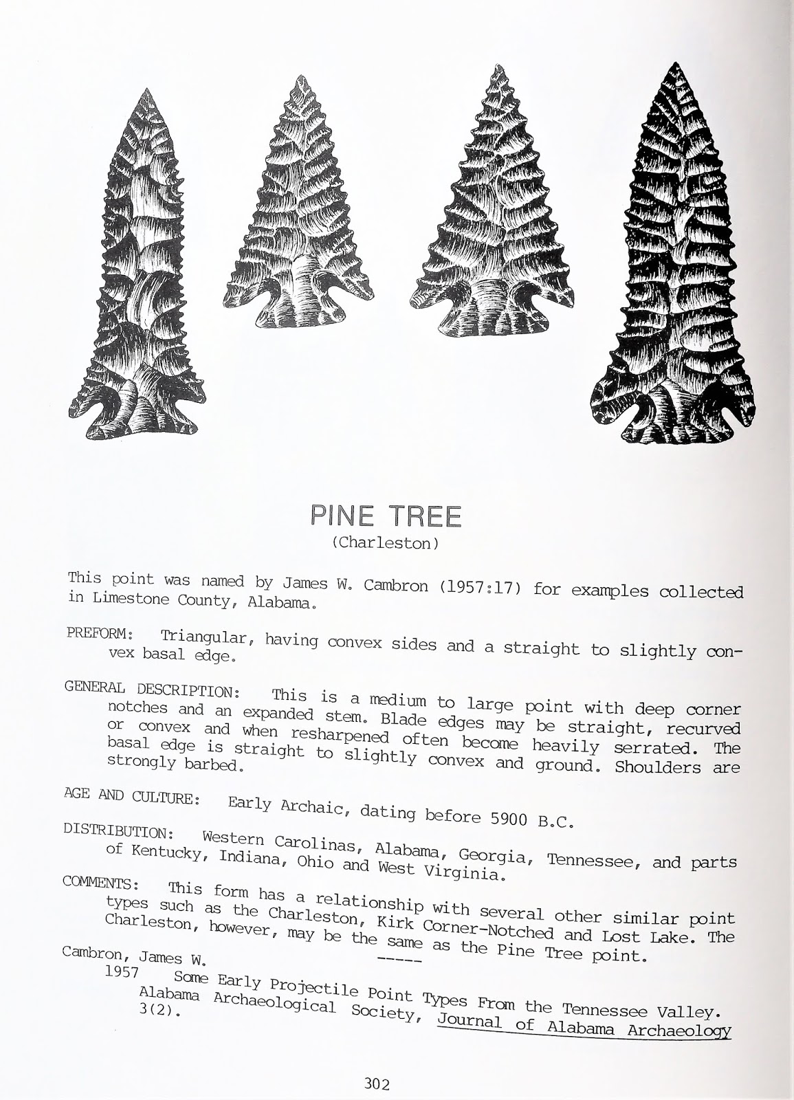
Perino (1991:130) described the typical Lookingbill point as follows: thin, small-to-medium-sized dart points with side notches. The blade was triangular and widest at sharp and angular shoulders. The notches were rounded and were as deep as they were wide. Sometimes, the notches were placed very close to a straight or slightly concave basal edge. Figure three is a photograph of a 1.6-inch long Lookingbill dart point I surface found in northern Colorado on July 9, 2015, at one of my most prolific sites call Shadows on the Trail. Does Perino's description match that point? 
 
Figure Three - 1.6-inch long Lookingbill dart point I found 
in northern Colorado on July 9, 2015.   

The Lookingbill point is currently the oldest side-notched projectile point type on the High Plains. According to radiocarbon dates, Lookingbill points were Early Plains Archaic around 7,000 years old. Up until that time, projectile points exhibited fishtails and indented bases and/or stems (figure four). Lookingbill points were dart points, spear points, or knife forms. In general, they were too large to use with bows and arrows, and according to current archaeological evidence, the bow and arrow did not show up in North America until several thousand years after Lookingbill points disappeared. 

What drove the side-notched innovation and where did that inspiration begin? If Lookingbill was the oldest side-notched point on the High Plains, did the people who inhabited the Helen Lookingbill Site invent the side-notched technology or did that development come from another region?

Figure Four - Early Archaic points earlier than Lookingbill points. In the photograph, there are 
indented bases, fishtails, stemmed, and two side-notched Lookingbill points for comparison.
John Bradford Branney Collection. 

There were other Early Archaic/Middle Archaic side-notched projectile point types in other regions outside of the High Plains and Lookingbill Site. Were those other side-notched point types the inspiration for Lookingbill points, or vice versa? What was the relationship between those other point types and the Lookingbill point type? Did they have common attributes with Lookingbill points? A few examples of Early Archaic to Middle Archaic side-notched point types from other regions include Big Sandy, Graham Cave, Northern, Godar, Hemphill, Hickory Ridge, Osceala, Raddatz, Newton Falls, White River, and the list goes on and on. Most of those side-notched projectile point types looked similar to the Lookingbill point type. It would be interesting to know whether Lookingbill technology ended up in those other regions or Lookingbill technology originated in one of those other regions.    

  
Figure Five - Map showing my chicken scratching of the geographic distribution for 
six Early to Middle Archaic side-notched projectile point types in North America.
Bitterroot was from the west and Big Sandy came from the southeast. 
The legend is to the right and the age is in B.C. (Before Christ).     

I did my own quick and dirty exercise in figure five to quench my curiosity about Lookingbill and its origins. My first objective was to sample six well-known Early Archaic/Middle Archaic side-notched projectile point types for geographic distribution and age. I found that Bitterroot (B.R.) was to the north and west of Lookingbill (L.B.), Long Creek (L.C.) was to the north of Lookingbill, and Logan Creek (Lo.C.) was to the east of Lookingbill. For good measure, I added two well-known, side-notched projectile points from the Midwest and Southeast; Graham Cave (G.C.) and Big Sandy (B.S.). My next action was to compare the ages of the six side-notched projectile point types. My hypothesis was that the oldest side-notched projectile point type was the technological origin for other younger side-notched projectile point types, including Lookingbill. 

To be consistent, I used one reference source for the geographical range and the reported age of five of the six side-notched projectile point types. My reference was Greg Perino’s three-volume set titled Selected Preforms, Points, and Knives of the North American Indians. In that book series, Mr. Perino documented most projectile point types known in North America. I knew there were other sources of information for those six projectile point types, but no other book series covered North American projectile point types in a consistent manner and with as much detail. The Perino books are a classic. Since Mr. Perino never documented the Long Creek projectile point type, I substituted Jeb Taylor’s Projectile Points of the High Plains for the geographical range and age of that one projectile point type.               
By looking at the reported age, I was hoping to determine a pathway for the origin of side-notched technology on the High Plains. Was Lookingbill or Bitterroot or Long Creek or Logan Creek the oldest technology? The oldest reported age for those point types would give me a hint as to where side-notching began. If Lookingbill points were the oldest that could raise the possibility that Lookingbill was the ancestral technology for the other side-notched projectile point types outside of the High Plains region.    

Figure Six - What I am calling Lookingbill projectile points. All surface found in Wyoming or 
Colorado. The points are in various stages of resharpening. The point on the far right 
was repurposed into an end scraper. John Bradford Branney Collection.  


The map in Figure five was the result of my plotting the geographic range and reported age for the six side-notched projectile point types. Based on the map, here were a few of my observations. 

1.  I only reviewed side-notched projectile point types in or surrounding the High Plains. My main objective was to determine if Lookingbill people spread side-notched technology to other surrounding regions or if Lookingbill people were the recipient of side-notched technology from an adjacent region. I limited my study to six projectile point types. I could have plotted every Early Archaic/Middle Archaic side-notched projectile point type in the United States, but I believed that would only confuse the matter.                      

2.  From the Missouri River on the east to the Great Basin on the west, it appears that Lookingbill points were the oldest side-notched projectile points at around 5000 B.C. or 7,000 years old.

3.  Kornfeld, Frison, and Larson (2010:113) declared that there might be a temporal and typological relationship between Bitterroot and Logan Creek. The older Lookingbill point type was geographically between Bitterroot to the west and Logan Creek to the east. Kornfeld, Frison, and Larson did not address any potential relationships between Bitterroot and Logan Creek with Lookingbill. Based on my initial findings, it was possible that Lookingbill side-notched technology expanded westward into Bitterroot and eastward into Logan Creek.

4.   Logan Creek had a similar form and age to the side-notched Hawken projectile point discovered in northeastern Wyoming. Frison (1978:199) noted the similarity and proposed a potential relationship between the two types. After a multi-year investigation of High Plains projectile point types, Taylor (2006:307) observed that the only bona fide Hawken points he encountered during his study were from the Hawken Site itself. Could the Hawken and Logan Creek projectile point types be one and the same? Do we need Hawken as a standalone projectile point type if its distribution is limited to one site?  

5.   Of the six side-notched projectile point types investigated, Graham Cave in Missouri was the oldest. Graham Cave and Lookingbill were separated by both space and time, and there does not appear to be an intermediary projectile point type bridging that space and time. A thousand years or so and a state or two separated Graham Cave from Lookingbill in Wyoming. Logan Creek bridged the geographical space between Graham Cave and Lookingbill but was younger than both projectile point types. 

6.  The arrow on my map in Figure seven demonstrates the possible dispersion of side-notched technology from Graham Cave dispersing west at an earlier time to Lookingbill dispersing east and west at a later time. 
7.  It was my conclusion that Lookingbill was not the source for side-notched technology in North America. It appears more likely that side-notched technology originated with Graham Cave or one of the older side-notched projectile point types in the Midwest or East. However, It is also my conclusion that it was plausible that Lookingbill technology in the High Plains fed side-notched technology to Bitterroot, Logan Creek, and Long Creek prehistoric cultures.   

Figure Seven - Possible side-notch technology dispersion. From the east (such as 
Graham Cave) to the west (such and then from Lookingbill to 
the north, east, and west.        

The side-notched innovation developed from a culture of people who recognized the benefits of notching. Based on my investigation, side-notched technology appears to have originated somewhere in the Midwest or eastern North America. Whether or not the technology originated in the "Old World" versus North America, I did not research that, and therefore cannot draw any conclusions on that. Resolving the mysteries as to where side-notched technology originated from requires more archaeological discoveries. In the meantime, the origins of side-notched technology provide us food for thought and something to debate and write about. 


References Cited 

Frison, George C. 
1978    Prehistoric Hunters of the High Plains. Academic Press. New York.  

Frison, George C. 
1983    The Lookingbill Site, Wyoming 48FR308. Tibewa. 20:1-16

Frison, George C. 
2014    Rancher Archaeologist. The University of Utah Press. Salt Lake City.   
Kornfeld, Marcel, George C. Frison, and Mary Lou Larson
2010     Prehistoric Hunter-Gatherers of the High Plains and Rockies.  Left Coast Press. California. 

Perino, Gregory
1997    Selected Preforms, Points, and Knives of the North American Indians - Volume I. Second Edition. Hynek Printing. Richland Center, Wisconsin. 

1991   Selected Preforms, Points, and Knives of the North American Indians - Volume II. Points and Barbs Press. Idabel, Oklahoma. 

2002   Selected Preforms, Points, and Knives of the North American Indians - Volume III. Hynek Printing. Richland Center, Wisconsin. 

Taylor, Jeb
2006   Projectile Points of the High Plains. Pp. 313-315. Sheridan Books. Chelsea, Michigan.  


About the Author


The historical fiction novels written by John Bradford Branney are known for their impeccable research and biting realism. In his latest blockbuster novel Beyond the Campfire, Branney catapults his readers back into Prehistoric America where they reunite with some familiar faces from Branney’s best-selling prehistoric adventure series the Shadows on the Trail Pentalogy.

John Bradford Branney holds a geology degree from the University of Wyoming and an MBA from the University of Colorado. John lives in the Colorado mountains with his wife, Theresa.

Thursday, July 25, 2019

Paleoclimatology 101 - The Younger Dryas Climactic Event


Figure One - Paleoindians competing with scavenging American Lions for a bison carcass,
sometime around the Younger Dryas Climactic Event. Photo courtesy unknown.    

In my last article, I discussed the "Great Meltdown" when the ice sheets and glaciers of the Wisconsin Ice Age began to melt. The meltdown started around 17,000 years ago, and for a few thousand years, the glaciers and ice sheets slowly retreated northward. Then around 12,900 years ago, the climate in the higher latitudes of the northern Hemisphere reversed course and it became colder. European scientists have known about this cooling event since the mid-twentieth century and dubbed it the Younger Dryas after a flower that grows in Europe in colder climates (figure six). By the 1990s, scientists around the globe were studying the evidence and effects from the Younger Dryas Chronozone in their areas of interest (YDC).      

Not only did ice age conditions return during the YDC from 12,900 to 11,700 years ago, but there were two other key events occurring in North America within the same general time-frame. About the same time that the YDC began, Clovis Paleoindian weaponry disappeared and so did forty or so megafauna species in North America. I am referring to extinct Pleistocene mammals such as mammoths, mastodons, ground sloths, camels, musk ox, horses, short-faced bears, dire wolves, saber-toothed cats, and others. 

Was the occurrence of these three 'Megaevents' - the YDC, the disappearance of Clovis weaponry, and the extinction of megafauna species - a coincidence, or is this the proverbial smoking gun for something else that was going on? 

Scientists have kicked the tires on the YDC at a breakneck pace with an attitude of winner-take-all. So far, the occurrence or coincidence of these three events has led to more questions and speculation than answers from the scientific community. 


Figure Two - My eighth and ninth books. CLICK TO ORDER

Some investigators claimed that the YDC brought back the same icy conditions that were around during the Last Glacial Maximum (LCM). Based on what I have read, that seems unlikely. Archaeologists Meltzer and Bar-Yosef (2012) stated that the biggest impact from the YDC was at higher latitudes in the northern hemisphere. They noted that by the time the YDC showed up, the great North American ice sheets -  Cordilleran and Laurentide - were mere shadows of their awe-inspiring selves. The ice sheets had retreated into Canada and were greatly diminished in both areal extent and thickness. The two archaeologists noted that greenhouse gases - methane and carbon dioxide - had increased to interglacial levels during the YDC which helped moderate the cooling trend of the climate. 

Some scientists wrote that the YDC showed up fast or lickety split, but Meltzer and Bar-Yosef disagreed, reporting that the archaeological evidence indicated that the YDC was a gradual and time-transgressive event, happening at different times in different areas with different overall effects. They also suggested that there were vast areas in the world that were completely unaffected by the YDC. Figure three illustrates the warming and cooling trends of the planet over the past 18,000 years. Around 14,000 years BP, the Earth was on a warming trend when a cooling trend that led to the YDC showed up. This cooling trend lasted for approximately 1200 years.   

Meltzer (2009) reported that during the YDC, glaciers in North America temporarily stopped melting and that a few glaciers actually expanded. He suggested that the climate in the northern part of the United States was cooler and drier. Meltzer's research estimated that average temperatures in the northern part of the United States dropped approximately nine degrees Fahrenheit. The YDC was a time of high winds, blowing sand and silt across the northern plains and the midwest regions of the United States. He pointed out that while the northern United States was colder and drier, the southeastern and midcontinent regions of the United States were warmer and wetter.
Figure Three -  From The Intriguing Problem of the Younger Dryas - What 
Does It Mean and What Caused It? by Anthony Watts.


You might be asking yourself what triggered the YDC? In my first paleoclimatology article, I introduced my readers to the Milankovitch Theory of ice age creation. I explained that this orbital theory was based on the gravitational effects of planetary bodies which ultimatly caused variation in the geographic distribution of insolation or solar radiation. I refer you to that article for review. 

There are at least two theories bantered about by scientists for the cause of the Younger Dryas. The more traditional theory proposed that a massive periglacial lake called Lake Agassiz (figure four) sprung a leak in its ice dam when the Laurentide Ice Sheet was in retreat. The breach released a massive amount of freshwater down the St. Lawrence waterway and into the North Atlantic. The deluge of freshwater interrupted the flow of the North Atlantic thermocline and Gulf Stream, the deep, warm current of water flowing north from the tropics. The warm, salty water from the Gulf Stream is responsible for moderating the climate of countries along the North Atlantic, such as Canada, the U.K., Iceland, Greenland, and Norway. 

From our high school science class we remember that fresh water is less dense than seawater (2.5 % less dense). When Lake Agassiz's freshwater flooded the North Atlantic, it floated on top of the warm, salty seawater, much like oil floats on water. The layer of freshwater prevented the warm, salty seawater from mixing and reaching the surface of the ocean. Temperatures in the northern hemisphere were no longer regulated by the Gulf Stream and a portion of the North Atlantic Ocean froze. Once this polar front established its footing, the cold expanded outward from the North Atlantic. 

Detractors of this theory pointed out that the amount of freshwater needed to shut down the circulatory forces of the North Atlantic thermohaline and Gulf Stream for that long of a period was astronomical. The detractors also point out that there is no geologic evidence for a massive flood along the St. Lawrence waterway when the ice dam burst on Lake Agassiz. 
      
Figure Four - Courtesy of Nature Magazine, April 1, 2010. 

The second and more controversial theory about the YDC was based on an extraterrestrial event (Firestone et al 2006). Firestone and his colleagues believed that a comet struck the Laurentide Ice Sheet, melting and breaking off massive blocks of glacial ice which ended up in the North Atlantic Ocean. The freshwater and icebergs weakened North Atlantic thermohaline circulation, triggering  abrupt climate cooling (at this stage this theory is similar to the Lake Agassiz theory). Firestone and his colleagues proclaimed that their theory explained the Younger Dryas, and the extinction of Pleistocene megafauna, and the decline of post-Clovis human populations. The investigators based their theory on the presence of iridium, Helium-3, firestorms, hollow floating spherules, microscopic diamonds, and glasslike carbon in the Younger Dryas aged "carbon rich black layer" (the black mat) found in Clovis sites around North America. 

Detractors to the 'extraterrestrial theory' jumped on it quickly and decisively. They asked Firestone et al where the crater was, and where the remnants of the comet were? Firestone  shot back that the ice sheet buffered the impact from the comet (figure five), therefore no crater. Detractors remained unsold based on a lack of scientific and geologic evidence. Scientific interest in the 'extraterrestrial theory' has waned over the years, but that does not stop its advocates and detractors from debating the pros and cons of the theory.

Is the extraterrestrial theory possible? 

Anything is possible. What about the critics of the extraterrestrial theory, don't they have a case? Of course they have a case, but we must remember that it is inherent in human nature to be skeptical about anything "out of the box". Some of the same critics of the extraterrestrial theory still cling to the "Clovis First" theory even after overwhelming evidence of "Pre-Clovis" has smacked them in the face. 

Figure Five.
    What happened to human populations before and during the YDC? What happened to the Clovis prehistoric culture?

In Hunter-Gatherer Behavior - Human Response during the Younger Dryas, a publication edited by Metin I. Eren (2012), the authors found little evidence of the YDC affecting the lives and behaviors of prehistoric hunter-gatherers around the world. The researchers reported that based on evidence at archaeological sites around the globe, there was more evidence in the YDC for continuity than there was for change. 

In the summary of this same book, Meltzer and Yosef (2012) stated that the efforts to link the YDC to human cultural change was a reasonable endeavor, but that initial enthusiasm often outpaced the empirical evidence found. YDC was mostly a northern hemisphere phenomena, affected the higher latitudes and not much of the rest of the globe. For example in North America, the authors noted that the YDC climate varied from cold and dry to the north, to warm and wet or cold and wet elsewhere on the continent. The authors concluded that the climate changes of the YDC were not globally synchronous or severe, and that there was little archaeological evidence that the YDC impacted human populations enough to motivate cultural change. 

What is my personal opinion on this? 

The Younger Dryas event cooled off the continent. Humans adapted to this change in climate, just like we always have and we always will. Clovis disappeared, but other Paleoindian cultures such as Goshen and Folsom filled the void. Perhaps, they were the same people. The weaponry Clovis used to hunt mammoths evolved into weaponry better suited to a bison-based economy. The now extinct megafauna species met two threats: a changing climate and intense hunting pressure from humans. The extinct mammal species failed to adapt to the threats from the climate and human predators, and went away.

Figure Six - Scientists named the return to near-glacial the Younger Dryas, 
after a flower (Dryas octopetala) that grows in cold conditions 
and that became common in Europe during that time.


Erin, Metin I.  2012   On Younger Dryas Climate Change as a Causal Determinate of Prehistoric Hunter-Gatherer Culture Change in Hunter-Gatherer Behavior - Human Response during the Younger Dryas, edited by Metin I. Eren. Left Coast Press. Walnut Creek.     

Firestone, Richard; West, Allen; Warwick-Smith, Simon   2006  The Cycle of Cosmic Catastrophes. Bear and Company. Rochester.    
Meltzer, David J.  2009  First Peoples in a New World - Colonizing Ice Age America. University of California Press. Berkeley.    
Meltzer, David J., and Ofer Bar-Yosef   2012  Looking for the Younger Dryas in Hunter-Gatherer Behavior - Human Response during the Younger Dryas, edited by Metin I. Eren. Left Coast Press. Walnut Creek.