Showing posts with label Clovis. Show all posts

Saturday, January 13, 2024

Heck of a Creek - A Shadows on the Trail Adventure

Figure One - The Ranch. 

Over the years, I have stopped at dozens of ranch houses to ask permission to hunt artifacts. Most of the time the landowners don’t care if you hunt as long as you treat their land with respect, in other words, keep your vehicle on existing roads and, above all things, close the gates behind you! Out of the many landowners I have asked permission, only a handful have denied me permission to hunt artifacts and it was always because sometime in the past some goofball did not follow the simple rules. They trespassed, left a gate open, drove through the landowner’s hayfield, or did something equally stupid. They did something to torque the landowner off and one thing I have learned about every landowner, they have very long memories.

I will never forget meeting one particular landowner. It was June 1, 2002, and I was heading back to Cheyenne from the southwestern part of Wyoming. I went hunting artifacts in that neck of the prairie, but I spent more time dodging rainstorms and mud than hunting artifacts. 
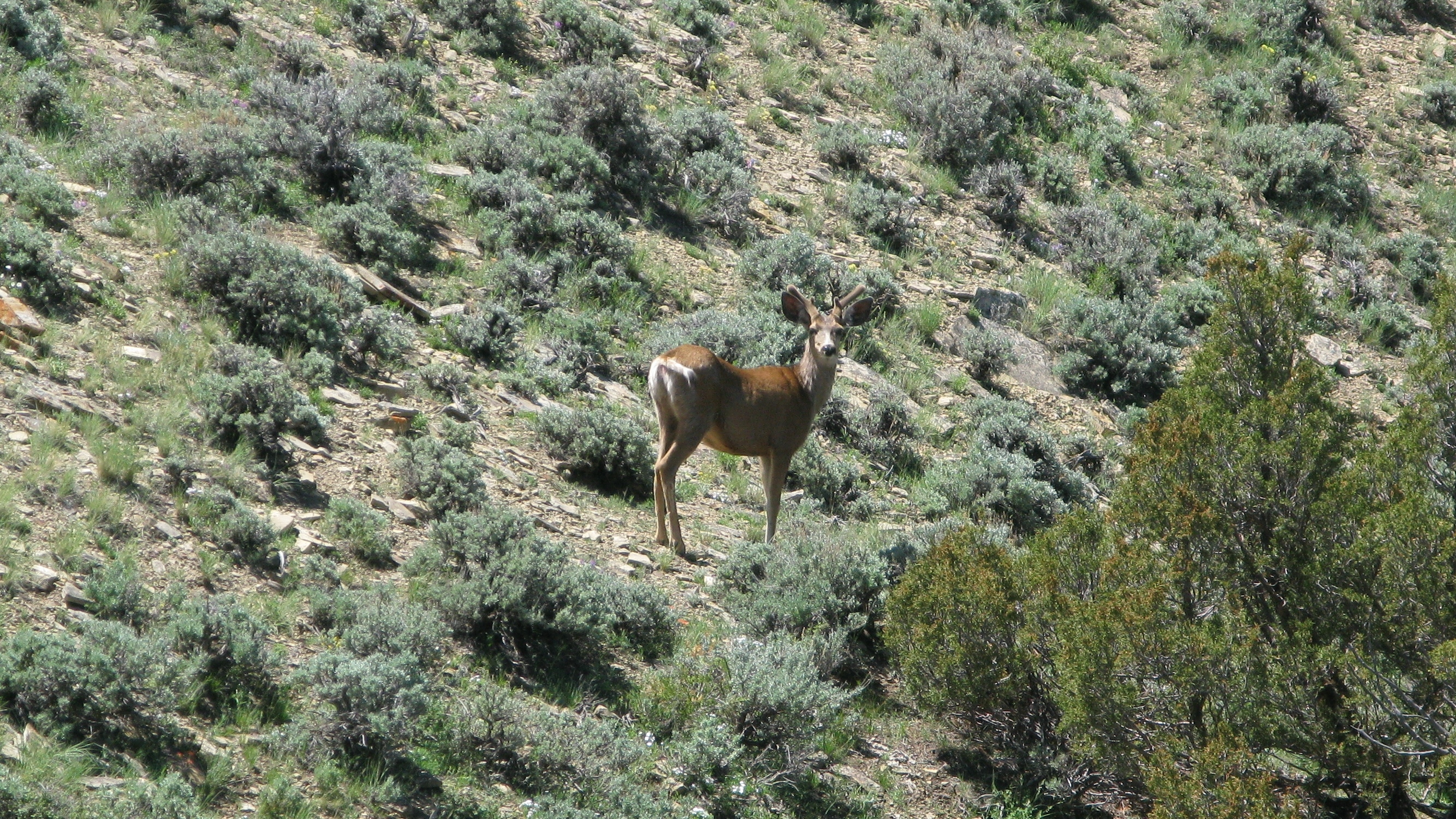


Figure Two - Mule deer buck on the ranch with his antlers still in velvet.
Photograph taken on May 28, 2014.  

Early June in Wyoming is an unsettled time for weather. In some parts of Wyoming, June can be spring while in other parts of Wyoming, June is still winter. I learned a long time ago to always pack extra clothes and waterproof items on my expeditions into Wyoming because June can be cold, windy, wet, and muddy.

So, there I was driving eastward down the interstate highway feeling like a whipped puppy dog. All I saw on my trip to southwestern Wyoming was rain, rain, and more rain. I felt lucky to even make it back to the main highway with all the gumbo mud on the backroads I traversed. I sure didn't want to drive back to Cheyenne empty-handed, so I decided to check out an area I had been eyeballing for some time on my topo maps. The place looked quite interesting, and it helped to pique my interest when the mapmakers named several topographic features after Native Americans. How could that go wrong?


Figure three – lichen-covered metate with inscribed lines on the surface.
Metate is 7.5 inches long. Found along the creek on May 30, 2013.  


I arrived at that spot on the map and started looking around for a ranch house. I wanted to ask permission before traipsing off onto someone’s private land. I found the closest ranch house and knocked on the door. After several dogs announced my presence, the rancher answered the door and peered down at me through a rusty screen door. The way he stared at me, you might have thought I was trying to sell him a vacuum cleaner or a set of encyclopedias. I introduced myself and explained to him why I was there. I always squeeze into my introduction that I am a native Wyomingite which most of the time scores a few brownie points. I ask permission and tell them I will only drive on the roads and the only thing I leave behind are my footprints (and hopefully fewer artifacts).

While the rancher sized me up, we talked about the weather and cattle prices. Before I knew it, the screen door flew open, and the rancher invited me into his home. As soon as I walked through the door, three cattle dogs surrounded me, investigating every scent I accumulated on my boots over the past three years. I smelled bacon as the rancher directed me to a chair at the kitchen table. After taking a brief detour to the stove to introduce myself to the rancher’s wife, I sat down at the kitchen table. I watched the rancher digging around on some shelves in the living room and the first thing my warped mind thought was he was looking for bullets for his Ruger pistol. While I kept an eagle eye on the rancher, in case I needed to make a hasty exit, his wife brought me a steaming cup of black coffee. The rancher walked back to the kitchen table and plopped down a bunch of rocks in front of me.

Figure Four - Pronghorn antelope checking me out along the creek.
Photograph taken on September 27, 2014. 


“What do you think of these?!” the rancher asked me with the confidence one has when laying down a winning hand at poker.

Wow, I thought to myself.

On the table in front of me were several broken prehistoric arrow points, the base of a large Besant dart point, a broken Pelican Lake knife form, and a perfect, tiny Hogback bird point. I started talking about what the artifacts were. I couldn’t help myself.

The rancher’s eyes lit up when he said, “I didn’t know that.” 

When I told the rancher and his wife the age ranges for some of their artifacts, they looked at me like I was from another planet. I am not sure they believed me. The rancher told me that his folks and grandparents hunted arrowheads on the property since the late 1800s. My heart sank a bit when I thought about all of the artifacts the family picked up in the last hundred years or so. As a side note, I prefer ranchers who couldn’t care less about artifacts and they leave the hunting up to me, but after all, it is their land.  


Figure Five – In situ photograph of a 3.3-inch-long Pelican Lake knife form made from Big Horn Chert. It was found on June 2, 2020, along a tributary to the main creek.    


After taking me to the basement to show me a fossilized skull of a very large Bison antiquus bull that the rancher found eroding from a riverbed, we went back to the kitchen table. By that time, the wife brought out two shoeboxes and set them down on the table. Well, I would never claim to be the brightest light bulb in the box, but I was pretty sure she was not going to show me any brand-new shoes in those shoeboxes.

The rancher’s wife meticulously unwrapped each artifact from paper towels and laid each one carefully down on the kitchen table. There were dozens of dart points, arrow points, knives, drills, and scrapers. I noticed a beautiful Goshen knife in the middle of a bunch of Late Archaic dart points. When I asked her about the Goshen knife, she told me the rancher’s brother found it in the sandy bottom of a nearby river when the water level was down. I then spotted another killer artifact hiding amongst the scrapers, a paper-thin Folsom point, made from a ghostlike, semi-translucent chalcedony. I would have loved to have found that Folsom point. By that time, I was thinking to myself that I wished that family would have taken up stamp collecting instead of arrowhead hunting. 


Figure Six - A 22.7-inch-long metate that I found half-buried with 
two manos along a tributary of the creek on August 22, 2022.
 

Then, the rancher’s wife plucked out what appeared to be a large cotton cocoon from the bottom of the shoebox. She held it up for me to see as if my X-ray vision could see through that thick glob of cotton. She unwound the cotton with the same delicate touch you might expect if she was unwrapping a priceless Faberge egg. When she was done, she teasingly held the artifact away from me so I could not see it. Then, with her cupped hand, she held the artifact in front of my nose. Nestled in the palm of her hand was a beautiful corner-notch tang knife. I am quite sure my jaw smacked the kitchen table. I most likely drooled out of the corner of my mouth. I lost all feeling in my brain as I stared at that glorious tang knife. You see, corner-notch tang knives may be more common in other parts of the country, but in dear old Wyoming, they are as rare as moose feathers. Then again, moose feathers might be more common in Wyoming than corner-notch tang knives.  

I was a bit speechless. I stared at the tang knife, then the wife, and finally the rancher. I wanted to know more about that artifact. They kept me in suspense with their smiles. Eventually, my mouth worked, and I formed two words as if I had never spoken English before.

“Tang knife,” I declared the obvious.

“Yes,” the wife replied with a giggle.

“Whe-where did you fi-find it?” I stuttered for the first time since third grade.  

“Here on the ranch,” the wife disclosed as nonchalantly as describing the weather.  

I wanted to ask them where on the ranch, but the rancher beat me to it. 

“She found that along the creek,” he said. “That’s one heck of a creek for finding arrowheads.”

“Eighteen years ago,” the wife added, “The year of the flood.”

“Seems like yesterday,” the rancher remarked. “That’s one heck of a creek.”

I already knew where I wanted to hunt if I could only get their permission.

“Have you ever found one?” the wife asked me.

I thought about that question. Over the years, I found what I thought were pieces of tang knives and perhaps some variants of tang knives, but a perfect corner-notch like that one? 

“One,” I answered. “I’ve found one.”

Yep, in all those decades and thousands of miles hiking, I had only found one measly, but nearly perfect, corner-notch tang knife.

 Note: since that visit, I have been fortunate to find several tang knives. Mostly from private land in Colorado.

After examining the rancher’s wonderful collection, I told them that I would like to check out ‘Heck of a Creek’. The rancher told me how to get there and we said our goodbyes, and I was off. I drove to that creek to find a corner-notch tang knife or a Folsom. That did not happen, but I found a bunch of chipping debris and some broken artifacts. The day was a success.  


Figure Seven - What have I got here? June 27, 2012, at the creek. 

I fast forward ten years and twenty-six days to June 27, 2012, and I am still finding artifacts along that “Heck of a Creek”. No, I haven’t found any Clovis caches or Folsom dart points, but I can’t complain about the hundreds of artifacts that I have found. I arrived at the creek that morning and started my search along the floodplain along the west side. Prehistoric people liked that side of the creek for some reason, and so did erosion. Back and forth I meandered across the plain like a tractor preparing the ground for planting. My eyes scoured the ground with the objective of not missing one single flake.


I remember that glorious day with its blue sky, brilliant sunshine, and northerly breeze as if it were yesterday. Even though it was late June, it was chilly and I wore a hoodie with the hood pulled snugly over the top of my noggin. The first interesting artifact I found was an odd-looking metate. I walked farther and found several more broken artifacts, but nothing to write home to Mother about. I was beginning to think that this was going to be one of those days when the hike was the most productive event of the day. Then, I spotted it, a buried artifact (figure seven). I didn’t know what kind of artifact it was or its condition, but I saw the tell-tale flaking and the beautiful material. Soon, I would set that artifact free from its grave.


Figure Eight - Pulled from the ground on June 27, 2012,
a 2.8-inches-long corner-notch tang knife.   

I reached down and pulled the artifact from the ground. I was as quiet as a closed coffin as I stared at the artifact. Then, I yelled into the wind something like, “Glory, hallelujah!”, but much less pious words popped out of my mouth. 

The freed artifact was a corner-notch tang knife (figures seven, eight, and ten). My hands shook as I photographed one of the rarest artifacts I have ever found. Then, I thought about the rancher’s wife and her tang knife. Two corner tang knives on the same creek, nearly impossible to fathom, but man that is one Heck of a Creek!

Although we do not know for sure how prehistoric people used or hafted corner-notch tang knives, Bob Patten (1999) provided an interesting possibility in figure nine. Since the hafting element is offset to one corner of a tang knife, people have come up with various possibilities as to how the knives were attached to a wooden or bone handle. I believe Patten’s theory is as reasonable as any solution, but we will never know for sure until a corner-notch tang knife is found with the hafting mechanism still intact.  


Figure Nine - Patten (1999)  


In addition to some great artifact hunting, the creek offers some fantastic scenery and lots of wildlife sightings. So, if the artifacts aren’t biting, there are always other diversions. Even today, I am walking the creek a couple of times per year in search of artifacts. Occasionally, I find a good one. Some time ago, the rancher lost his interest in artifacts. He definitely has his hands full running his cattle ranch.

The landscape in the area has dramatically changed in the last decade. It is no longer the pristine place it once was. The rancher and his neighbors received offers that they could not refuse. Hundreds of wind turbines tower over their ranchland for tens of miles in every direction. The landscape has forever changed and not for the better. As I listen to the whirring and humming of wind turbine blades, I have to conclude that yes, it once was a “Heck of a Creek”.


Figure Ten - The Find of the Day. 

References Cited

Patten, Bob

            1999    Old Tools – New Eyes, Stone Dagger Publications, Denver.            


About the Author

John Bradford Branney is a geologist, prehistorian, and author. Born in Wyoming, he currently lives in the Colorado mountains. He has published eleven books (working on twelve) and many magazine articles about archaeology, wandering, and geology. He has collected prehistoric artifacts his entire life and has documented an extensive artifact collection.    


Wednesday, February 22, 2023

Spanish Diggings Orthoquartzite

Figure One - Colby-variety Clovis point on the left and Hell Gap point on the right, both 
surface-recovered approximately thirty miles west-northwest of Spanish Diggings. I 
believe the raw material for both points is Spanish Diggings orthoquartzite. 
John Bradford Branney Collection.      

The Spanish Diggings prehistoric rock quarries lie on the northwest flank of the Hartville Uplift in eastern Wyoming. The Hartville Uplift is an elongated, north-northeast trending structural arch that is twenty-five miles wide and forty miles long and ranges in elevation from 4,700 to 6,100 feet above sea level (figure two). The Hartville Uplift was created during the Laramide Orogeny in the late Cretaceous around fifty to seventy million years ago. The Laramide Orogeny was a geological event of grand importance and involved intense mountain building and structural basin creation in western North America from Canada through the United States and into east-central Mexico.  

Figure Two - Google map of eastern Wyoming looking to the northwest. The Hartville Uplift 
is marked and the location of Spanish Diggings is circled in orange. PRB and DB in black 
are Powder River Basin and Denver Basin, respectively. Photo courtesy of geowyo.com.   

For archaeologists and artifact collectors, the Hartville Uplift is known for its quality cherts and orthoquartzites coming from the Paleozoic and Mesozoic Era rocks. Prehistoric miners at Spanish Diggings found the prized orthoquartzite in outcrops of the Morrison-Cloverly formations of the Mesozoic Era. Mottled gray quartzites and chert were found in the Morrison formation while colorful and exceptionally fine-grained orthoquartzites were found in the Cloverly formation. The orthoquartzites in the Cloverly came in various shades of gray, yellow, brown, lavender, purple, and red. Not all of the sandstone in the Cloverly formation was silicified enough to produce high-quality orthoquartzites which makes the rock quarries at Spanish Diggings even more exceptional. Outcrops of Morrison-Cloverly cover an area of approximately 1.5 square miles in the vicinity of Spanish Diggings. Those outcrops are bordered by Miocene and Oligocene rocks.  

The Spanish Diggings were some of the largest prehistoric rock quarries in the world. For over thirteen millennia, prehistoric people came to Spanish Diggings and mined orthoquartzite and chert from the hills and valleys. When the prehistoric people left the rock quarries, they carried the raw material with them and spread their finished artifacts and chipping debris across the countryside for hundreds of miles in every direction.


Figure Three – Looking west and slightly south at the hills and valleys of Spanish Diggings.
In the distance is beautiful Laramie Peak. Photograph by Neil A. Waring.

Reher (1991:272) reported a mapping project that calculated the size of Spanish Diggings at approximately 30,000 square meters using the three primary quarry complexes: Barbour, Dorsey, and Spanish Creek. Another 18,000 square meters and approximately 170 stone circles could be included if the campsite and workshop areas near the Barbour quarries were counted. If eleven other clusters of quarries with less debitage were added to the three primary quarries, an additional 120,000 square meters and 500 stone circles could be counted in the Spanish Diggings complex. Reher added that investigators were still discovering additional mining activity and quarry sites at Spanish Diggings. 

Author’s Story Part One: My first memory of Spanish Diggings came from the mid-1960s. I was attending grade school in eastern Wyoming, and if memory serves me, I was in the fourth or fifth grade. The school scheduled an assembly when Jerry and Mae Urbanek were to show us prehistoric artifacts that they found at a place called Spanish Diggings. That was the first time I ever heard of Spanish Diggings, and I was pretty excited about the exhibition. When the school scheduled assemblies I was usually excited for a couple of reasons; assemblies got me out of the dreaded classroom and most assemblies were somewhat entertaining. Secondly, that specific lecture intrigued me because the artifact bug bit me early in life. I had already gone artifact hunting with my family several times and my mother inherited her father’s artifact collection of spearpoints, arrowheads, and scrapers. I was completely fascinated with that collection, and I was hooked on artifacts and prehistory at a very early age.   

My family lived in the right place at the right time for artifact collecting. There was not much to do in rural Wyoming in the 1960s and 1970s except hunt and fish and shoot and explore the outdoors. We were fortunate enough to live in a wide open country with large ranches and mostly friendly ranchers. After I found out about the assembly, I rushed home and told my parents. My mother reminded me that Mae Urbanek was a semi-famous Wyoming historian and author who wrote several books on Wyoming history and its early settlers. That fact only added to my enthusiasm.     


Figure Four - Clovis platter cache found southeast of Spanish Diggings. The material
appears to be Spanish Diggings orthoquartzite. John Bradford Branney Collection.    

Cowboys first discovered the prehistoric rock quarries and mining pits at Spanish Diggings sometime before 1870. At that time, the locals believed that Spanish conquistadors dug the mines in their pursuit of precious metals. A rancher-cowboy by the name of Joseph Stein was often credited with coming up with the name Spanish Diggings sometime around 1882. In 1893, a Cheyenne man named Sidney Bartlett brought more attention to what he called the “Mexican mine” by writing an article about the quarries for the San Francisco Examiner. Stein and another rancher named Lauk were so convinced that there was gold at Spanish Diggings that they hired part-time workers to prospect for gold there from 1886 to 1891. The two ranchers and their workers never reported finding any gold or other precious metals at Spanish Diggings.   

The news about Spanish Diggings eventually caught the attention of academic institutions and museums. In 1894, renowned geologist Wilbur Knight from the University of Wyoming visited the site and documented nineteen mining operations on the north slope of a mesa. He reported vertical shafts, horizontal tunnels, trenches, circular pits, mine debris, and large, crude stone tools. The narrative soon changed from the Spaniards digging for gold to prehistoric Americans digging for toolstone.     

Author’s Story Part Two: The day of the Urbanek show-and-tell did not arrive soon enough for me, but it ended as a huge letdown for this young tyke. At that age, I was not an artifact expert by a long shot, but it seemed to me that Mr. and Mrs. Urbanek showed us a bunch of plain ole rocks that they dubbed prehistoric artifacts. I didn’t know what false advertising was at the time, but that was what I thought of their collection. I expected much more, like my grandfather’s collection with glorious spear points, knives, stone axes, and other cool artifacts. I wonder if I revisited Urbanek’s artifact collection today if I wouldn’t have a different opinion. I imagine their artifacts looked very similar to the artifacts that George Dorsey and associates found in 1891 (figure seven). I learned one thing from the Urbaneks' lecture; I wanted to see Spanish Diggings for myself! That night, I lobbied my parents to take us to Spanish Diggings in the spring. 


Figure Five - George Dorsey
at Spanish Diggings. 

One of the early scholars to visit Spanish Diggings was George A. Dorsey, the curator of the Field Columbian Museum in Chicago. In 1891, ranchers Stein and Lauk picked Dorsey up at the railroad station in Guernsey, Wyoming, and headed out to Spanish Diggings. In 1900, Dorsey published a short paper on his visit to the prehistoric rock quarries. The following paragraph was Dorsey’s observation after studying one of the many outcrops of orthoquartzite in the Cloverly formation.    


“Examining one of the walls of the wash we find a solid stratum, thirty or more feet thick, of flint, or rather of sandstone, which has been worked by silicious waters, thus forming quartzite. This stratum is of variegated color, passing from yellowish brown to violet gray, varied with shades of pink, violet, yellow, purple, etc., the whole stratum thus producing a most beautiful and remarkable color effect.”

-George A. Dorsey (1900:238-239)


Figure Six -
Sketch map of Spanish Diggings area by R. F. Gilder (Holmes 1919).      

Dorsey was not alone in visiting Spanish Diggings. There were many organized expeditions by scholars and visitors in the late 1800s and early 1900s. Most of the expeditions were focused on filling barrels and wagons with artifacts and raw materials to take back to their colleges and museums. There was little research done on the rock quarries themselves or the prehistoric people who created them. Some of the early artifact finds reported were digging tools made from antler, stone, and bone; rock wedges; and grooved mauls. For several decades, countless crusades of scholars, recreationists, flintknappers, and artifact collectors carted off thousands of tons of artifacts and raw material from Spanish Diggings, creating a huge archaeological data gap and forever altering the quarries’ prehistoric record. That data gap did not stop George A. Dorsey from prognosticating how the prehistoric miners exploited the raw material at Spanish Diggings.  


“The upper two or three feet of rock is very brittle and does not chip well; indeed, it occurs not as a solid mass, but, owing to long weathering, in long thin sheets or irregular blocks.

“After the soil had been penetrated, the workmen encountered the upper unworkable rock through which it was necessary to excavate to a considerable depth before the denser masses of workable material and the jasper and chalcedony nodules were encountered. On account of the broken character of the upper mass of the quartzite bed such excavations were not necessarily difficult operations. Furthermore, it is possible to believe that this work could be carried on with tools similar to those which would be found efficacious in working the exposed stratum down in the valley.”

-George A. Dorsey (1900:240)


Figure Seven - Typical quarry finds from 
Dorsey's expedition to Spanish Diggings.  


Quartzite was the most abundant tool stone that prehistoric Americans mined at the Spanish Diggings rock quarries. There are two types of quartzite. The first type is metaquartzite which started out as a sedimentary rock called sandstone. In metaquartzite, the original sand grains and silica cement were recrystallized through heat, pressure, and chemical action by a geological process called metamorphism. Metaquartzite is very hard because it is primarily quartz. Metaquartzite tends to have deformed interlocking quartz grains (Andrefsky 2005).

Spanish Diggings is famous for a second type of quartzite called orthoquartzite or silicified sandstone. Orthoquartzite is a clastic sedimentary rock called sandstone which was made almost entirely of quartz sand grains. In orthoquartzite, the quartz sand grains were not deformed like metaquartzite but instead were bound together with silica cement through a geological process called silicification. The prehistoric miners at Spanish Diggings discovered that the high-quality, fine-grained orthoquartzites were near perfect for making tools and projectile points.  


Figure Eight -
A knife form with a broken tip that I found on one of my earlier visits to Spanish Diggings. The prehistoric individual used orthoquartzite from one of the quarries.    

Author’s Story Part Three: If you ask a Wyoming native when spring will arrive, he or she might inform you that spring arrives in June. If you inquire when summer begins, that same Wyoming native might tell you summers begin sometime in early July and end in August. If you question what the rest of the year is called, that same Wyoming native will inevitably answer, “Winter in Wyoming!” 

Spring finally arrived in Wyoming and my family was ready for their pilgrimage to Spanish Diggings. My parents knew a rancher from our church who owned a big chunk of Spanish Diggings. The rancher gave us permission to hunt rocks on his property and even mentioned that we might find some “petrified turtle shells” if we were lucky. He even drew us a little map of how to get there so that we did not get lost. Even today, Spanish Diggings is not an easy place to find.

My father drove us to Spanish Diggings in our Chevy station wagon. I remember the roads became progressively worse the closer we came to Spanish Diggings on the map until we were traveling on what was best described as a glorified cow trail. My father stopped smack dab in the middle of a wide ravine filled with sagebrush and rattlesnakes. The ground next to the car was littered with chunks of orthoquartzite and chert cobbles from the mine pits. There was so much refuse on the ground that it made hunting for artifacts nearly impossible. It was literally like looking for a needle in a haystack. We spent the day hiking up and down the hills. We found a few primitive tools and worked pieces but nothing special. Our little adventure was probably not worth the wear and tear on our car. The best finds of the day were five or six fossilized turtle shells. I remember finding those as if it was yesterday. I often wonder what happened to those fossils. I regret not taking better care of them.  


Figure Nine - 
SHADOWS on the TRAIL Pentalogy 

I worked on a large ranch and farm a few miles northwest of Spanish Diggings every summer in high school and through a summer or two of college. I occasionally visited Spanish Diggings on my dirt bike in the evenings after work. I found nothing but broken cobbles and crude hammerstones. In all my visits to Spanish Diggings, I only found one small projectile point made from chalcedony. From what I read in the literature, my lackluster result in finding finished artifacts was not much different than that of the early scholars and visitors. When explorer William Henry Holmes visited Spanish Diggings in the early twentieth century, here was how he characterized the trip.


“Nothing whatever was found in the finished state, and even partially worked specimens were not numerous. The refuse about the pits is characterized by the large size of the partially shaped rejects.”

-W. H. Holmes (1919:213) 


Prehistoric Americans came to the quarries, selected good pieces of raw material, roughed them out, and took them elsewhere to finish them up as stone tools and projectile points. Looking back at the grade school assembly, the Urbanek collection might not have been so bad after all. Rough slabs and barely worked cobbles of quartzite and chert were probably typical, even back in the early cowboy days. Perhaps that was the reason why the early cowboys thought Spaniards dug the mines and not prehistoric Americans; the mine debris on the ground was not indicative of who created it!

These days I find a lot of artifacts made from orthoquartzite. I suspect the raw material came from Spanish Diggings but that might not be the right conclusion. Like other popular high plains raw materials like Knife River or Flattop, Spanish Diggings orthoquartzite has its own imposters and lookalikes coming from other areas. I even discovered a prehistoric rock quarry in northeastern Colorado where the orthoquartzite looks remarkably similar to a few flavors of Spanish Diggings orthoquartzite.   

Well, that’s my story. I hope you enjoyed it. No matter what happens to Spanish Diggings or me in the future, I will always cherish those early memories of Spanish Diggings!            


References Cited

Andrefsky, William Jr. 2005. Lithics – Macroscopic Approaches to Analysis. Cambridge University Press. Cambridge.  

Dorsey, George Amos. 1900. An Aboriginal Quartzite Quarry in Eastern Wyoming. Field Columbian Museum, Publication 51, Anthropological Series, Volume II, Number 4. Chicago. 

Holmes, W. H. 1919. Handbook of Aboriginal American Antiquities. Part I – Introduction to Lithic Industries. Smithsonian Institute. Bureau of American Ethnology. Bulletin 60. Washington D.C.   

Reher, Charles A. 1991. Large Scale Lithic Quarries and Regional Transport Systems on the High Plains of Eastern Wyoming – Spanish Diggings Revisited in Raw Material Economies Among Prehistoric Hunter-Gatherers edited by Anta Montet-White and Steven Holen. University of Kansas Publications, 19.   


About the Author


John Bradford Branney grew up in Wyoming and from an early age developed a passion for everything prehistoric. He has amassed and documented a huge collection of prehistoric artifacts and fossils. After high school, Branney earned a B.S. degree in geology from the University of Wyoming. Branney then chose a career in the oil and gas industry where he worked for thirty-plus years. During that career, he earned an MBA in finance from the University of Colorado. Branney has written numerous magazine and journal articles about prehistoric artifacts and high plains archaeology. He is currently writing his twelfth book and the sixth book in his prehistoric adventure series the SHADOWS on the TRAIL Hexalogy.    

Friday, April 6, 2018

Who Dun It? Paleoindian Projectile Point Typology Part II


Figure One - What do you call these High Plains surface finds?  The three critical attributes I used to identify them were; 1). Pronounced basal concavity, 2). Carefully executed diagonal flaking, and 3). Edge grinding. The longest point is 3.2 inches. 
John Bradford Branney Collection.  

Identifying Paleoindian projectile points from the High Plains by type is often more art than science. Deciding what kind of projectile point is in your hands can lead to some hand wringing, especially for those projectile points that lie somewhere ‘between’ two known projectile point types. I call these borderline points, 'tweeners'. One of the more confusing arrays of projectile points is the Paleoindian/Early Archaic points with indented bases. For decades, people sorted most indented base projectile points from the High Plains into two buckets; Clovis if it had flutes and Yuma or Plainview if it had basal thinning and no flutes. No doubt that the differences between the various indented base projectile points made by 

My latest book. Click for Information

Paleoindians were subtle enough to get away with that for a while but as more sites were discovered, archaeologists named more projectile point types. Today an indented-based Paleoindian projectile point can fall into a number of buckets depending on its specific attributes. These buckets include Clovis, Goshen, Folsom, Plainview, Jimmy Allen, Midland, and I am sure I am missing a few. And that's just for the High Plains! Figure one shows one group of indented base points from Wyoming and Colorado that I believe are a single type. Do you agree with these points being a single type, and if so, what type do you think they are? I call them Jimmy Allen points. 

The similarities between projectile point types can sometimes be striking and the differences subtle. I have seen two identical projectile points made with the same technology and of similar age called different point types just because they were found in different parts of the United States (figure two). I bet you have, too. This is precisely why I do not get too hung up on projectile point-type names. In my opinion, collectors and archaeologists go way overboard trying to cubbyhole projectile points into specific types. I think there are too many projectile point types now! Coming up with a new projectile point and naming it becomes a status thing, a feather in someone's Easter bonnet. Instead of focusing on the similarities with existing projectile point types, even from another region, the focus is on the differences. An example of this situation is the Jimmy Allen points above in figure one. There is a lot of variation between these points but I lump them into a single projectile point type: Jimmy Allen. If someone found these in the midwest, they might be calling them something else entirely.  
Figure Two - The Texas Panhandle point on the left is 
called Plainview while the northern Colorado point 
on the right is called Goshen. 
Can you see any morphological differences? 
I can't. The longest point is 2.4 inches.
John Branney Collection.  

Editorial: I am straying off topic a bit so let me reel myself in and stay away from the politics of proposing a new projectile point type. Well, maybe I will reel it in after this paragraph. Let me finish my thoughts on the topic. It is almost impossible for an amateur archaeologist or collector to have a new projectile point named and recognized. Professionals have a forum for naming and documenting new projectile point types and there is a lot of politics involved. It can go the other way as well, such as denying the existence of a projectile point type in a certain region. Texas archaeologists have denied the existence of Agate Basin points in Texas for some time as if a manmade border suddenly stopped Agate Basin people from crossing the Texas border twelve thousand years ago. I have personally found and seen Agate Basin points in Texas, but since professional archaeologists have not found them in situ, they deny their existence in the Lone Star State. In most cases, collectors and archaeologists in Texas call them Angostura even though morphologically they are Agate Basin. Politics! Whew, now, that I have my bellyaching out of the way, back to the topic at hand.     

Imagine that you or I discover a new prehistoric site while surface hunting. We find several examples of a different style of projectile point that we have not seen before. Since these are surface finds, there is no archaeological or geological context so we do not know the age of the prehistoric culture they came from. We can take an educated guess on the time period based on the flintknapping style and technology used. The projectile points kind of look like an existing projectile point type, but they are not a complete match. Our projectile points have a couple of features that make them different. We wonder if we found a new projectile point type or just came across a creative prehistoric flintknapper from a known prehistoric culture. What do we do? What would you do? I know a couple collectors who have found new projectile point variants on the surface sites where they hunt and these collectors christen these variants with a localized name. Professional archaeologists might not recognize that local projectile point type, but local collectors do.    

Selecting and recognizing the critical attributes in projectile points can be difficult and subjective. At one extreme, we focus on the general attributes and fit our group of projectile points into an existing projectile point type. At the other extreme, we focus on the minute differences from an existing projectile point type, without regard for variation along a common theme.

Figure Three - What would you call these surface-found projectile points? I call them Midland points
based on three attributes; 1). Thin, 2). Indented to flat bases, and 3). Fine, abrupt, non-invasive
pressure retouch forming regular and straight margins. The longest point is 2.5 inches.
You might call them something entirely different.
John Bradford Branney Collection   

If the description for an existing projectile point type is too tight and rigid, we end up with a plethora of new projectile point types that might reflect the differences in quality, craftsmanship, and/or workmanship, but not the actual prehistoric culture that made them. If the description for an existing projectile point type is too loose and flexible, we might accept large variations which may actually be a change in technology and/or prehistoric culture.

The bottom line is (yes, I do have a bottom line); A PROJECTILE POINT TYPE IS ONLY A NAME. Don't get too hung up on it! The key element in projectile point identification is doing the homework required to identify your Paleoindian projectile point to the best of your ability! But just because you or I or Joe Blow thinks a point is a specific projectile point type doesn't make it necessarily so.   


                 Wanna another Paleoindian Who Dun it? 
Read the second edition of SHADOWS on the TRAIL! 

Figure FourCLICK for INFO on SHADOWS on the TRAIL

In case you missed "Part I of Who Dun It", CLICK LINK