Showing posts with label Bruce Bradley. Show all posts

Thursday, March 25, 2021

The Midland Point Mystery Along the Shadows on the Trail


Figure One - High Plains Midland Projectile points from the author's collection.
The longest point is 2.4 inches long. Photo by John Bradford Branney.  

Some people claim that Midland projectile points are unfluted Folsom projectile points while other people profess that Midland was its own archaeological complex, separate from the Folsom archaeological complex. The people with the latter opinion call attention to the Midland-only site named Winkler-1 discovered by amateur archaeologists in southeastern New Mexico (Blaine et al. 2017). There, artifact hunters surface collected Midland points from an active sand blowout. Perhaps, the Midland projectile points above in figure one started out as Folsom projectile point preforms and were too thin for the knappers to flute, or maybe the knapper was not skilled enough to flute a Folsom point, or perhaps Midland projectile points were deliberately made that way. We will never know for sure, at least until the next great discovery.

The Midland projectile point type is somewhat of a 'catchall' for several other types of projectile points. It is my experience that collectors and professionals alike tend to lump different types of indented Paleoindian projectile points under the Midland projectile point type umbrella. I have seen what I would call Goshen-Plainview, Allen, and even Cody Complex points categorized as Midland points. That does not make me right and those other people wrong. It just demonstrates the difficulty people have differentiating Midland projectile points from other thin, indented base Paleoindian projectile points. I have that same difficulty.  

Figure Two - The first historical fiction book in my five-book series titled
the Shadows on the Trail Pentalogy. Available at Amazon.com.   

Well-respected archaeologist Bruce Bradley (2010:475) provided one of the better definitions of the Midland projectile point. He described Midland flaking as wide and relatively shallow, producing projectile points with flat cross-sectionsBradley noted that pressure flaking was often used along the edges and the bases of Midland projectile points, but that for the most part, the Midland knapper did most of the flaking using percussion! He noted that Midland points showed abrupt and continuous marginal retouch along the edges which thinned and narrowed the Midland points enough to eliminate the negative bulbs produced from the percussion flaking process

Have you ever checked out the edgework on a well-made Midland point? Check out figure three! Wide and shallow flaking across the face of the projectile point with pressure flaked "mouse nibbling" around the circumference of the edges. In his analysis, Bradley concluded that Midland points were technologically distinct from Folsom points.


Figure Three - 1.8-inch-long Midland projectile point
surface found 9/2/1997 in Logan County, Colorado.
Note flaking and edgework. John Bradford Branney Photo.

Bradley made that last argument from a technical flintknapping perspective. He stated that Midland points were more than just unfluted Folsom points. He noted that there were two distinct technological differences between Folsom and Midland in the final shaping and thinning, and the marginal retouch. Bradley suggested that Goshen-Plainview points complicated Paleoindian projectile point identification due to several similarities in form and technology. Anyone who has attempted to differentiate between Midland and Goshen-Plainview points can vouch for Bradley's opinion.  

One important fact not to lose sight of; as of this article's revision date, there were no 
radiocarbon dates or geological/stratigraphic relationships that conclusively resolved the temporal relationship or contemporaneity of Folsom and Midland!


Figure four. Broken backs surface found in Wyoming. 
Folsom (upper) and 
Midland (lower) projectile point
bases. John Bradford Branney photo and collection.   
Bradley (2010:474) noted that even though investigators have found Folsom and Midland points at the same sites, they have not discovered them together in a well-defined archaeological context that provides the geologic evidence required for proposing that the two projectile point types were in use at the same time! Finding Folsom and Midland points together at a single-episode bison kill site would be an example of the evidence required to define contemporaneity (both point types occurring at the same period of time).  

Bradley noted that archaeological investigators have not found Midland points in sealed stratigraphic units without Folsom points which seems to at least suggest that Folsom and Midland points were linked. He noted an exception to that; the Gault site in Texas where investigators found a Midland point three centimeters above a Folsom point in a sealed stratigraphic unit, indicating that the Midland point was younger than the Folsom point. What we do not know is whether those three centimeters represent one week or one year or one hundred years or more of sedimentation. 

Figure five - The King of Kings. 1.65-inch-long Folsom projectile
point surface found by Albert Bellgardt in Montrose
County, Colorado. 
John Bradford Branney Collection.

What is your opinion on Midland and Folsom?


Based on radiocarbon dating, it appears that Goshen-Plainview projectile points were coeval or contemporaneous with Folsom/Midland (Waters and Stafford 2014). Goshen-Plainview and Folsom knappers brought pressure flaking to its perfection. When Midland showed up, it was a short technological leap to Goshen-Plainview or vice versa. A much easier leap than to Folsom. Archaeological evidence is now leaning towards Goshen-Plainview, Folsom, and Midland overlapping in space and time, at least during a short period. 

I believe that Paleoindians did not adopt and use just one projectile point type at a time, but like modern-day deer hunters who use different calibers of rifles, Paleoindians used a variation of projectile points. Archaeological evidence just needs to catch up so that some of these theories can be either supported or denied based on evidence.    


Blaine, Jay C., S. Alan Skinner b and Molly A. Hall
2017  The Saga of Winkler-1: A Midland Site in Southeast New Mexico in Paleoamerica.   Texas A & M University.  

Bradley, Bruce A. 
2010  Paleoindian Flaked Stone Technology on the Plains and in the Rockies in Prehistoric Hunter and Gatherers of the High Plains and Rockies by Marcel Kornfeld, George C. Frison, and Mary Lou Larson. Left Coast Press. Walnut Creek, California.  


Waters, Michael R., and Thomas W. Stafford Jr.
2014   Redating the Mill Iron Site, Montana, in American Antiquity 79(3).


The historical fiction novels written by John Bradford Branney are known for their impeccable research and biting realism. In his latest blockbuster novel Beyond the Campfire, Branney catapults readers back into Paleoindian America where they reunite with some familiar faces from Branney’s best-selling prehistoric adventure series the Shadows on the Trail Pentalogy.

John Bradford Branney holds a geology degree from the University of Wyoming and an MBA from the University of Colorado. John lives in the Colorado mountains with his wife, Theresa. Beyond the Campfire is the eleventh published book by Branney.


Monday, March 15, 2021

Platter Chatter Along the Shadows on the Trail


Platter Chatter

By John Bradford Branney


Figure 1 – a trio of Clovis platters cached in southeastern Wyoming and discovered by a highway department employee in the late 1950s or early 1960s. For scale, the middle artifact is 7.9 inches long. John Bradford Branney photograph and collection.

Figure 1 is a photograph of a cache of three Clovis platters surface found in the late 1950s or early 1960s by a gentleman who worked for the Wyoming Highway Department. The exact location of the find is unknown, but according to his niece, he found the cache while working on a highway in southeastern Wyoming. Based on that information, I assume he was in either Goshen or Laramie County. When the finder passed away, much of the information about the Clovis platter cache died with him.

The finder’s niece ended up with the collection. She knew little about artifacts and placed the cache into storage, where it lay for approximately twenty-five years. Approximately seventeen years ago, Frank Parrish, a collector and hunter of Paleoindian artifacts, met the niece at a rock and gem show in Tucson, Arizona. Long story short, Mr. Parrish made an offer for the cache, and she accepted. Mr. Parrish saved this cache from a lifetime stuck in a storage locker and/or eternal obscurity. Mr. Parrish sold the cache to me in 2021.

In the literature, authors refer to this type of artifact as platters (Patten 1999; 2005), or ovate bifaces (Waters and Jennings 2015), or discoidal cores (Bradley, Collins, and Hemmings 2010). I will refer to them as Clovis platters because that best physically describes them. These platters have features that are distinctive to Clovis biface thinning, such as wide flakes and spacing, overshot and over-the-face flake scars, alternate flake sequencing, end thinning, and, on at least one of the platters, Clovis biface striking platforms as shown in Figure 2 (Bradley, Collins, and Hemming 2010: p 67).

Figure 2 – Clovis biface platform characteristics from page 67 in 
Clovis Technology by Bradley, Collins, and Hemming.

In Clovis Technology, Bradley pointed out that overshot flaking was not a common feature and that in most cases it resulted from knapping errors. The same authors noted that overshot flaking was one marker for defining Clovis biface technology. The authors proclaimed that investigators have yet to find discoidal cores (platters) in Clovis camp or kill site settings, prehistoric quarries, or near the sources of the same raw material.

What did the Clovis people use platters for? I like to think of them as portable rock supplies. They either cached them as a backup plan or used them on their wandering to make tools and projectile points. Tankersley (2002: p. 115) described how eight of the nine pieces in the Crook County Clovis Cache were a rock type called Tiger Chert, and the source for Tiger Chert was more than three hundred miles southwest of where Harold Erickson discovered the Clovis cache in Crook County, Wyoming. A Clovis individual, or perhaps a beast of burden such as a dog, hauled these Clovis platters and stone tools from southwestern Wyoming for three hundred miles before caching them within a thin lens of red ochre in the Fox Hills Formation in northeastern Wyoming. Obviously, the Clovis individual never returned to retrieve the cache.

The maker of the Clovis platters in Figure 1 used what appears to be orthoquartzite material from the Spanish Diggings prehistoric rock quarry in southwestern Niobrara County, Wyoming. For thousands of years, prehistoric people mined orthoquartzite and chert from the Mesozoic Cloverly Formation at Spanish Diggings. The orthoquartzite from the quarry ranges in color from bright yellow to gold, tan, brown, gray, pink, lavender, and purplish hues. 


Figure 3 – Looking in a westerly direction at the prehistoric rock quarry called 
Spanish Diggings in Niobrara County, Wyoming. On the horizon is Laramie Peak.
Photograph by Neil A. Waring.

Based on what we know about the provenance of the cache, the highway worker who found them was working on some road in southeastern Wyoming. If that were the case, the finder could have been anywhere from ten to one hundred or so miles from Spanish Diggings when he discovered the cache.


Figure 4 – Side A of Clovis platter A 321 made from Spanish Diggings orthoquartzite. This platter
is 6.9 inches long (176 mm). John Bradford Branney photograph and collection.


Clovis platter A 321 (Figure 4) is an oval-shaped biface that is 176 millimeters long, 102 millimeters wide, and approximately 19 millimeters thick near the center of the biface. It has a width-to-thickness ratio of 5.4. The rock type is a moderate orange-pink orthoquartzite with hues of gray throughout the matrix and scattered manganese dendrites. Clovis knappers’ special skill was percussion flaking, and this platter reflects that expertise. The flaking scars are classic Clovis technology: thin, straight, wide, and long. The marginal edges have a minor amount of secondary sharpening. There is no visual evidence of red ochre on the surface or within the cracks or hinges of the platter.

Figure 5 - Hillside made of red ochre.   
Oftentimes, Clovis people covered or buried their caches in a mineral called red ochre. Ochre is an earthy pigment consisting of ferric oxide and clay minerals. It varies from shades of light yellow to brown to red. There is archaeological evidence that prehistoric people in both the Old and New Worlds used red ochre as a pigment for painting, a preservative, an abrasive, and a packing material. Neanderthals in Europe used ochre as early as 250,000 years ago, and investigators have found ochre in Upper Paleolithic graves in Europe and in one Clovis grave in North America.

Investigators have found red ochre in a variety of contexts within North America, such as occupation floors, burials, stone tool caches, and at least one prehistoric mine. Investigators have found red ochre on a Paleoindian grinding slab and on stone artifacts, foreshafts, main shafts, atlatl fragments, and cave walls. Although it appears red ochre had ritualistic uses, it also served several practical applications.


Figure 6 – Clovis platter A 321 A made from a moderate brown Spanish Diggings 
orthoquartzite. This platter is 7.9 inches long (201 mm). 
John Bradford Branney photograph and collection.

Clovis platter A 321 A (Figure 6) is a leaf-shaped biface that is 201 millimeters long, 119 millimeters wide, and approximately 30 millimeters thick near the center of the biface. It has a width-to-thickness ratio of 4. The rock type is a moderate brown orthoquartzite with scattered blotches of pale yellowish-brown. The flaking scars are typical of Clovis; wide, long, and traveling a good distance across both faces of the biface. The marginal edges show little secondary sharpening. There is evidence of battering and crushing along the edges.

Master flintknapper Bob Patten (1999:93-94) wrote that although platters were many times larger and heavier than ultrathin knife forms, the production process was similar. As a master flintknapper, Patten opined that Clovis platter technology was as sophisticated as any knapping technology used by later cultures. Patten proposed that the Clovis people might have carried these platters in a leather sling or pouch, and when the timing was right, they would cache them or convert them into projectile point preforms or tools. Tankersley (2002: 116) found a diagonal pattern of red ochre on two of the Crook County bifaces, suggesting that the owner of the bifaces might have wrapped them in sinew or leather.

To replicate Clovis platters via flintknapping, Patten described how he beveled, battered, and abraded the edges to make it easier to remove large flakes via percussion. Then, he spaced each blow with his hammer wide enough so that the flake scars overlapped ever so slightly.


Figure 7 – Side A of Clovis platter A 321 B. This platter is 8 inches long (203 mm). 
On one edge, the knapper intentionally notched the platter 
and on the other edge, the knapper had prepared to notch it with 
Clovis biface platforms (see figures 2 and 8). 
John Bradford Branney photograph and collection.

Clovis platter A 321 B (Figures 7 and 8). This is the most interesting platter of the trio. The platter shape lies somewhere between oval and leaf-shaped. It is 203 millimeters long, 130 millimeters wide, and approximately 26 millimeters thick for a width-to-thickness ratio of 5. The knapper used a grayish orange pink orthoquartzite to make the artifact.

The knapper intentionally notched one side of Platter A 321 B in the middle of the edge. He or she was preparing to notch the other edge when the knapper cached it with the other two platters. The opposite edge (Figure 8) shows at least two Clovis biface platforms, which the knapper would have used to strike and detach flakes with the intention of notching into the body of the biface. Notches weaken the biface body enough to split the platter into sections, which the knapper would use for Clovis projectile points or other stone tools.


Figure 8 – "A" marks the beaten and the battered edge of side B of A 321 B. 
"P" marks typical Clovis biface platforms. The Clovis knapper was starting to notch this edge. 
Compare the characteristics of the platform with Figure 2 above. 
John Bradford Branney photograph and collection. 

So, why did the Clovis people cache these platters and other tools? Archaeologists and collectors have discovered Clovis-type artifacts in forty-eight states, Mexico, and Canada. The Clovis people traveled long distances in a relatively short time period. Based on thirty-two radiocarbon ages, Waters, Stafford, and Carlson (2020) proposed that Clovis technology lasted from around 13,050 to 12,750 calendar years ago. Clovis people were explorers, and when they reached areas where they were unsure of the raw material supply, they left a cache of stone tools and rock material to retrieve later. 

Time for me to get a little “preachy.” One big lesson I learned from this cache is to fully document the details and location of every artifact I find or acquire as accurately and completely as possible to ensure relevant information about the artifacts is available after I am no longer above ground. We should all do this. Artifacts are history, just not pretty rocks or works of art.

It is unfortunate that when the finder of this important discovery passed on, the provenance details went with him. I have a dozen or so questions about this cache, but those answers will never be known. We will never know where he found the cache, or under what circumstances. Was the cache found on the surface or buried? Did the road-building equipment unearth it? Did the finder investigate whether there were other pieces in the cache? My list of questions is practically endless. Unfortunately, I can ask all the questions I want until I am blue in the face, but I will never know the answers.


References Cited

Bradley, Bruce A., Michael B. Collins, and Andrew Hemmings
2010     Clovis Technology. International Monographs in Prehistory. Archaeological Series                 17. Ann Arbor, Michigan.

Patten, Bob
1999     Old Tools – New Eyes. Stone Dagger Publications. Denver.

2005     People of the Flute. Stone Dagger Publications. Denver.

Tankersley, Kenneth
2002     In Search of Ice Age Americans. Gibbs Smith, Publisher. Layton, Utah.

Waters, Michael R. and Thomas A. Jennings
2015     The Hogeye Clovis Cache. Texas A & M University. College Station.

Waters, Michael R., Thomas W. Stafford Jr., and David L. Carlson
2020     The Age of Clovis – 13,050 to 12,750 cal yr B.P. in Science Advances, Vol. 6, No.                 43.

About the Author


John Bradford Branney is a Wyoming native, an author, a geologist, a prehistorian, and an associate editor of Prehistoric AMERICAN. He has written thirteen books and over one hundred articles on Prehistoric America and life in general. Branney is currently writing the second edition of WINDS of EDEN, the third book in the prehistoric adventure series SHADOWS on the TRAIL Hexalogy. He lives in the northern Colorado mountains with his family.


CLICK for JOHN Bradford BRANNEY Books


Wednesday, March 11, 2015

The Hell Gap Complex Along the SHADOWS on the TRAIL


Figure One - Flintknapping technology from Agate Basin to Hell Gap projectile points. 
The point on the far left is Agate Basin, while the other three points are Hell Gap. For  
 scale, the Agate Basin point is 2.45 inches long. 
John Bradford Branney Collection.   


In figure one, I photographed four high plains projectile points from my collection: on the far left is a 2.45-inch-long Agate Basin projectile point, and on the right are three Hell Gap projectile points. Bradley (1991:382) proposed that the manufacturing process for Hell Gap projectile points was an outgrowth of a well-developed Agate Basin projectile point technology. He postulated that the production sequence was the same for both projectile point types: first, there was percussion thinning and shaping, followed by pressure thinning and shaping. Bradley stated that the makers of Hell Gap projectile points just terminated their flintknapping process earlier than the makers of Agate Basin projectile points. 

Fortuitous circumstances led to the discovery of the Hell Gap archaeological site in southeastern Wyoming. Since its discovery over sixty-some years ago, Hell Gap has become one of the most important archaeological discoveries in North America and the type site for the Hell Gap projectile point. 

On May 22nd, 1958, James Duguid and his family were travelling north along a gravel road between Guernsey and Lusk, Wyoming, along the eastern flank of the Hartsville Uplift. Along came one of those afternoon rain showers that temporarily flooded a low spot in the road. The floodwaters forced the family to stop and allow the water on the road to drain. The family bided their time by walking and artifact hunting in the immediate area. Duguid discovered some interesting artifacts in an arroyo and promised himself that he would return the next day to finish the hunt (Duguid 2009:313-314).


Figure Two - A 2.55-inch-long Hell Gap projectile point/knife form surface found
on private land in Morgan County, Colorado, and made from a pretty
caramel-colored j
asper. John Bradford Branney Collection. 

Duguid and a friend returned to the site the next day, and Duguid found a complete Agate Basin point along with a lot of flintkapping debris. He returned to the site with his father and another friend the very next day, on May 24th. Duguid's father, Otto, discovered what appeared to be a Paleoindian projectile point eroding from a cutbank. That point was later determined to be a Hell Gap projectile point. Between his father's Hell Gap point and his Agate Basin point, Duguid recognized that they stumbled upon a very special place. However, he was hesitant to report the site to professional archaeologists because he knew that there were archaeologists who failed to report and document other excavated Paleoindian sites in the area. Duguid was worried that the same fate might befall his newly discovered secret.   

Figure Three - The Hell Gap Paleoindian site
in the late 1960s.


In the fall of 1958, James Duguid began working on his geology degree at the University of Wyoming. In the fall of 1959, Duguid reported the site to University of Wyoming anthropology professor George A. Agogino. The professor convinced Duguid to take him to the site to investigate it. Duguid and his father escorted Agogino to Hell Gap Valley, and the rest was history, or in that case, prehistory. 

Sixty-plus years later, archaeologists are still investigating the Hell Gap Site. Hell Gap remains one of the most important archaeological discoveries in the Western United States during the past one hundred years, and that came about because of an avocational archaeologist named James Duguid. 


Figure Four - A mixed hand of Agate Basin and Hell Gap projectile points collected
from the High Plains. Which points are Agate Basin and which are Hell Gap?
My answer is found in the last paragraph of the article. 


George Agogino (1961) defined the Hell Gap projectile point type from examples found in Hell Gap Valley and the archaeological site. Hell Gap projectile points were medium to large lanceolate-shaped points that were similar to Agate Basin points, except that the Hell Gap projectile points bore shoulders. Hell Gap stems were long and contracting. The blade edges from tip to base were either straight-to-concave or convex-to-straight-to-concave. The basal edges of the points were often ground and polished, which gave investigators an indication as to how far up the projectile point was hafted. The basal corners ranged from sharp to ground and polished smooth. 

 
Figure Five - Two examples of Hell Gap projectile points (o and p) found
in situ with Agate Basin projectile points at the Agate Basin site in 
eastern Wyoming.  Frison and Stanford (1982:101)


Based on excavated bison kill sites, it appears that Hell Gap Paleoindians participated in large, well-organized communal hunts for meat acquisition, much like their Paleoindian predecessors. Figure five is a photograph of a few projectile points excavated in a bison bonebed at the Agate Basin site in eastern Wyoming (Frison and Stanford 1982:101). In that photograph, two of the projectile points (o and p) were classic Hell Gap projectile points with shouldering. Those Hell Gap points were excavated from the same bonebed and stratigraphic level as Agate Basin projectile points. In addition to those two Hell Gap points, there were other examples of Hell Gap points excavated from the Agate Basin bonebed, which provided evidence of a relationship between the two point types. Based on the evidence, it seems likely that Paleoindians used Hell Gap points contemporaneously with Agate Basin points at the Agate Basin site. 
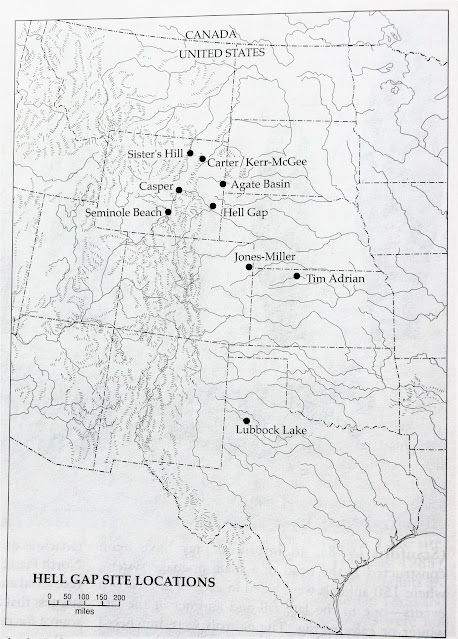

Figure Six - Select Hell Gap sites from Stanford (1999:318)


Stanford (1999:318) published the map in figure six of important Hell Gap sites along the High Plains. He noted that the number of Hell Gap sites was less than Cody and Folsom sites for the same area. Stanford made no assumptions or conclusions as to why there were fewer Hell Gap sites. 

The Casper Site was originally discovered by avocational archaeologists. George Frison (1974) investigated the Casper Site in central Wyoming and determined it was a late-autumn bison kill site where Hell Gap Paleoindians harvested around one hundred animals by immobilizing them in the deep and shifting sands of a parabolic dune.  

Using several Hell Gap point specimens from the Casper Site, Bradley (2010:487) proposed a special bifacial reduction process. He noted that Hell Gap flintknappers achieved the general shape and regularity of the biface by serial percussion thinning on one side with a hammerstone. In the world of flintknapping, serial percussion thinning usually results in the arrises, i.e. the high ridges at the flake margins, trending in the same direction. The Hell Gap flintknappers skillfully controlled the spacing and the thinning flakes that crossed the surface of the biface. Many of the thinning flakes reached or almost reached the other edge of the biface. 

Figure Seven - Clovis point and three 
Hell Gap projectile points from the
Casper site (Frison 1974:74). 
The Hell Gap flintknappers then turned the bifaces over and percussion thinned from the opposite edge, creating bifaces with cross-sections resembling a parallelogram. After serial percussion thinning, the Hell Gap flintknapper shaped and straightened the margins of the biface using direct percussion with an antler or hammerstone or by selective pressure flaking. Hell Gap flintknappers used platform isolation and moderate-to-heavy grinding to prepare the striking platforms for percussion flaking. Unlike Clovis striking platforms, Hell Gap flintknappers used smaller and more convex-shaped striking platforms. Bradley found in his study of the Hell Gap projectile points from the Casper site that a few flintknappers used percussion flaking exclusively, while others chose to retouch the margin edges with pressure flakes, particularly near the tips and bases of the bifaces. Ultimately, the finished bifaces ended up with lens-shaped cross-sections. Figure seven represents the forms and flaking patterns of one Clovis and three Hell Gap projectile points found at the Casper Site.    

Cassells (1997:79) reported that in the summer of 1972, rancher Robert Jones Jr. uncovered bones and artifacts while levelling a ridge near his home near Wray, Colorado. Jones contacted a local anthropologist named Jack Miller, who conducted a few test excavations in the bonebed. Miller recognized the significance of the site and contacted archaeologist Dennis Stanford at the Smithsonian Institute. Full-scale excavations at the Jones-Miller site occurred between 1973 and 1978. 


The Jones-Miller investigations uncovered the bones of approximately three hundred bison in a shallow arroyo above the Arikeree River floodplain. Based on bison tooth eruption patterns, the investigators determined that the animals were most likely killed during three episodes over one or more winters. The projectile points that the investigators found were mostly of the Hell Gap variety. Taylor (2006:207) reported and photographed what appeared to be Agate Basin points found with the Hell Gap points from a single kill episode at Jones-Miller. That either meant that Agate Basin and Hell Gap hunters were cooperating at that bison kill, or the mixture of point types represented the same complex using two different styles of points. In my opinion, the situation at Jones-Miller was most likely the latter. 

Stanford (1999:316-318) observed that during the refurbishment or resharpening of Hell Gap points, the flintknappers could narrow the blade edge enough to make the points indistinguishable from Agate Basin points. Peck (2011:55) lumped Agate Basin and Hell Gap into the same archaeological complex based on the overlapping projectile point technology and the association between the two-point types at several archaeological sites such as Agate Basin, Carter-Kerr McGee, and Jones-Miller. Peck reported an age of ca. 10,500 to 10,000 BP for Agate Basin materials and an age of ca. 10,000 to 9,500 BP for Hell Gap materials at the Hell Gap Site in Wyoming (Irwin-Williams et al. 1973:52). To obtain the age of the materials in calendar years, the radiocarbon ages must be corrected.         

Based on the archaeological evidence at Jones-Miller, the investigators proposed that Paleoindians trapped the bison in a topographical trough. The investigators found evidence that the Paleoindians might have used an enclosure or corral around the trough. Since the bison harvest took place in the wintertime, the investigators hypothesized that the entrance leading into the trough might have been slick with snow and ice, making it difficult for the beasts to escape. The hunters then trapped and dispatched the beasts with spears and possibly spearthrowers. Jones-Miller remains the only excavated Hell Gap site in Colorado. 

Figure Nine - From left to right: Two Hell Gap projectile points and two Alberta 
projectile points from my collection. Note the shouldering on the Hell Gap
projectile points and the stemming on the Alberta projectile points.  

What happened to the Hell Gap projectile point technology?     

Figure nine is a photograph of four projectile points from my collection. These projectile points represent a plausible technological transition from the shouldering on the first two Hell Gap points on the left to the stemming on the two Alberta points from the Cody Complex on the right. The notion that Hell Gap projectile point technology evolved into Alberta projectile point technology is also supported from a temporal perspective. Kornfeld et. al. (2010:237) reported that the Alberta component at the Hudson Meng bison kill site in Nebraska was approximately the same age as the Hell Gap component at the Casper bison kill site in central Wyoming. Both sites were dated to around 10,000 years BP (uncorrected radiocarbon date). While Hell Gap hunters were trapping bison in a parabolic sand dune in Wyoming, Alberta hunters were trapping bison in an ancient arroyo in Nebraska.    

I hope you enjoyed the article. I am currently writing the sixth book in my SHADOWS on the TRAIL Hexalogy. Check out the series if you enjoy adventures about Paleoindians living on the High Plains.

Oh, I almost forgot about the projectile point types in figure four above. From left to right, the point types are Agate Basin, Hell Gap, Agate Basin, Hell Gap, and Agate Basin.     

Until next time, HAPPY TRAILS!  


References Cited.  

Agogino, George A. 1961. A New Point Type from Hell Gap Valley, Eastern Wyoming. American Antiquity 26: 558-560, Salt Lake City.  

Bradley, Bruce A. 1974. The Lithic Technology of the Casper Site Materials in The Casper Site: A Hell Gap Bison Kill on the High Plains, edited by George A. Frison. Academic Press. New York.   

Bradley, Bruce A. 2009. Bifacial Technology and Paleoindian Projectile Points in Hell Gap: A Stratified Paleoindian Campsite at the Edge of the Rockies, edited by Mary Lou Larson, Marcel Kornfeld, and George C. Frison. 

Bradley, Bruce A. 2010. Paleoindian Flaked Stone Technology on the Plains and in the Rockies in Prehistoric Hunter-Gatherers of the High Plains and Rockies. Third Edition. Edited by Marcel Kornfeld, George C. Frison, and Mary Lou Larson. Left Coast Press. Walnut Creek.      

Cassell, E. Steve. 1997. The Archaeology of Colorado. Revised Edition. Johnson Books. Boulder.   

Duguid, James O. 2009. A Paleoindian Site Discovery in Hell Gap: A Stratified Paleoindian Campsite at the Edge of the Rockies, edited by Mary Lou Larson, Marcel Kornfeld, and George C. Frison.    

Frison, George A. 1974. The Casper Site: A Hell Gap Bison Kill on the High Plains. Academic Press. New York.   

Frison, George C., and Dennis J. Stanford. 1982. The Agate Basin Site. Academic Press. New York.

Irwin-Williams, Cynthia, Henry Williams, George Agogino, and C. Vance Haynes. 1973. Hell Gap: Paleo-Indian Occupation on the High Plains. Plains Anthropologist. 18(59):40-53.  

Peck, Trevor R. 2011. Light from Ancient Campfires. AU Press. Edmonton.  

Stanford, Dennis. 1999. Paleoindian Archaeology and Late Pleistocene Environments in the Plains and Southwestern United States in Ice Age People of North America, edited by Robson Bonnichsen and Karen L. Turnmire. Oregon State University Press. Corvallis.    

Taylor, Jeb. 2006. Projectile Points of the High Plains. Sheridan Books. Chelsea.   


About the Author. 

John Bradford Branney started collecting prehistoric artifacts in Wyoming with his family at the ripe old age of eight years old. He has amassed and documented a prehistoric artifact collection numbering in the thousands. He has written eleven historical fiction books and over ninety papers focused on Paleoindians, prehistoric artifacts, and geology. Branney holds a B.S. degree in geology from the University of Wyoming and an MBA in finance from the University of Colorado. He lives in the Colorado Mountains with his family.